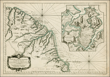
A Chart of the Coast of Guyana, From the Entrance of the River Orinoco (in the Lat. 8°. 30'N. Long 61°. W. from London) to the Entrance of the River Amazones by R. Waddington.
All of our maps are authentic antique maps, printed or drawn on or about the date shown in the description. In rare instances when we offer facsimiles, we will specifically describe the map as a later facsimile and include the date of publication. Certificates of Authenticity are included with each item.
Map Maker
Fast, Global Shipping
Last year we shipped over 4,500 antique maps to more than 50 countries. Maps are shipped Monday through Friday year-round. If an order is received before 2 PM PST, we will ship the order that day. If an order is received after that time, we will ship the next day. We ship maps either flat in custom packages or in specially ordered thick tubes. Shipping rates are provided as part of the checkout process.
Description
Scarce early English sea chart showing the coast of Guyana, with insets of the River Orinoco, published in London by Mount & Page.
The map extends from the entrance thereof to St. Thomas, and the River of Surinam and places adjacent.


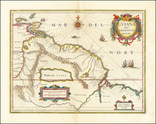
![[El Dorado] Partie de Terre Ferme ou sont Guiane et Caribane Augmentee et Corrigee suivant les dernieres Relations . . . 1656](https://storage.googleapis.com/raremaps/img/small/47044.jpg)
![[ Venezuela ] A Map of the Caracas](https://storage.googleapis.com/raremaps/img/small/103834.jpg)