|
||

|

|
|

|
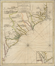
Previously Unrecorded Dutch Sea Chart of the Atlantic Coast of North America.
Previously unknown Dutch sea chart of the coast of North America from Trinity Harbor, North Carolina to Cape St. Ann, Massachusetts, which is apparently a copy of JOhn Seller's 1675 map of the same title.
The cartouche is identical to an earlier Doncker chart with the same title, but this is an entirely new copper plate.
Hendrik Doncker was a famous bookseller in Amsterdam, who started at the age of 22 years and ran his shop successfully for fifty years. He published his first sea atlas around 1659. Due to the fact that Hendrik Doncker corrected and improved his charts more frequently then his competitors, his business was quite successful and there was a high demand for his works and this reflected also the various improved and corrected editions of sea atlases he published. This map was published in a composite sea atlas by Pieter Goos, who was 'one of the best known maritime booksellers of Amsterdam' (Koeman), he published a number of different sea-atlases or pilot books, his work was very much derivative. With his 'Zee-Atlas' he relied heavily on Hendrick Doncker's 'Zee-Atlas' of 1659.
Hendrik Doncker was a prominent bookseller in Amsterdam best known for his sea charts and nautical atlases. He issued his own original charts, which he updated frequently, and also worked with colleagues like Pieter Goos, for example to produce the pilot guide, De Zeespeigel. He died in 1699, after fifty years in business. His plates then passed to Johannes van Keulen.
![[ Cape Hatteras to New York City ] The Coast of the United States of North America; from New York to St. Augustine: Drawn and regulated according to the latest Surveys and Astronomical Observations By Edmund Blunt. Additions to 1839 & 1840](https://storage.googleapis.com/raremaps/img/small/84684.jpg)
![(Southeast United States) Carte de la partie sud, des Etats Unis de L' amerique septentrionale [Map of the southern part of the United States of North America]](https://storage.googleapis.com/raremaps/img/small/98738.jpg)