


|
||

|

|
|

|
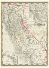
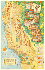
Attractive map of California, colored by county.
Predates a number of Southern California counties. Includes a detailed inset plan of San Francisco. Shows towns, roads, railroads, rivers, lakes, mountains, missions, etc.
An attractive map from one of the most important 19th century American commercial map publishers.
Asher & Adams was a New York publishing firm known for their atlases. Notably, their maps were some of the first to prominently exhibit railroad lines, even if this meant a slight reduction in topographical detail. They specialized especially in state and county maps of the United States.
Asher & Adams was a New York publishing firm known for their atlases. Notably, their maps were some of the first to prominently exhibit railroad lines, even if this meant a slight reduction in topographical detail. They specialized especially in state and county maps of the United States.
![[ California & Southwest ] Granata Nova Et California](https://storage.googleapis.com/raremaps/img/small/72305.jpg)