|
||

|

|
|

|
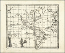
First state of Faden's beautiful map of America and the Western Hemisphere, with the words "O Rare Columbus" at the top of the title cartouche.
The map illustrates the discoveries of Captains Cook and La Perouse along the NW Coast of America and throughout the Pacific, including the Sandwich Islands. Pope Alexander's 1493 Line of Demarcation is shown in the Atlantic, separating the Portuguese and Spanish possessions. The Antarctic Icy Sea is noted, along with a note reading Cook's Nec Plus Ultra 71 Degrees 10 Minutes Latitude South, January 30th 1774.
While the Bay of the West is not shown, there is an annotation in the Northwest which reads A'ASS TOPULSE or GREAT SEA of the Indians SEA of THE WEST of the Geographers. The Arctic Icy Sea or Hyperborean Sea is named. Excellent detail along the Northwest Passage, with several additional annotations. Several discovery and exploration annotations appear in the Pacific and Atlantic Oceans, relative to late 18th century discoveries.
Includes an attractive cartouche with the words "O Rare Columbia" engraved in the clouds above the cartouche.
William Faden (1749-1836) was the most prominent London mapmaker and publisher of the late-eighteenth and early-nineteenth centuries. His father, William Mackfaden, was a printer who dropped the first part of his last name due to the Jacobite rising of 1745.
Apprenticed to an engraver in the Clothworkers' Company, he was made free of the Company in August of 1771. He entered into a partnership with the family of Thomas Jeffreys, a prolific and well-respected mapmaker who had recently died in 1771. This partnership lasted until 1776.
Also in 1776, Faden joined the Society of Civil Engineers, which later changed its name to the Smeatonian Society of Civil Engineers. The Smeatonians operated as an elite, yet practical, dining club and his membership led Faden to several engineering publications, including canal plans and plans of other new engineering projects.
Faden's star rose during the American Revolution, when he produced popular maps and atlases focused on the American colonies and the battles that raged within them. In 1783, just as the war ended, Faden inherited his father's estate, allowing him to fully control his business and expand it; in the same year he gained the title "Geographer in Ordinary to his Majesty."
Faden also commanded a large stock of British county maps, which made him attractive as a partner to the Ordnance Survey; he published the first Ordnance map in 1801, a map of Kent. The Admiralty also admired his work and acquired some of his plates which were re-issued as official naval charts.
Faden was renowned for his ingenuity as well as his business acumen. In 1796 he was awarded a gold medal by the Society of Arts. With his brother-in-law, the astronomer and painter John Russell, he created the first extant lunar globe.
After retiring in 1823 the lucrative business passed to James Wyld, a former apprentice. He died in Shepperton in 1826, leaving a large estate.
![Suite Du Bresil . . . [2 maps]](https://storage.googleapis.com/raremaps/img/small/103662.jpg)