|
||

|

|
|

|
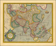
Nice example of Senex's map of Asia.
John Senex was one of England's best known map makers at the beginning of the 18th Century, who was appointed Geographer to Queen Anne. This is a very attractive map of Asia, combining the latest information available to Senex with the many misconceptions of the continent prevalent in Europe at the time. Many rivers, towns, lakes, roads, and other information is presented from the Urals to the East Indies.
The map tracks the currents in the Indian Ocean by month and also notes the currents along the east coast of SE Asia and the Philippines.
An inset of "ye supposed N. Coast of Asia" is given in the lower left "to avoid too great a contraction of the scale." The map is most confused in the seas to the north of Japan. The "Land of Iess" and "Company's Land" are shown as indistinct and large land masses, and north of them is an open "Eastern Ocean." Senex includes a charming cartouche, which shows two figures in Asian dress, along with flora and fauna of the continent.
John Senex (1678-1740) was one of the foremost mapmakers in England in the early eighteenth century. He was also a surveyor, globemaker, and geographer. As a young man, he was apprenticed to Robert Clavell, a bookseller. He worked with several mapmakers over the course of his career, including Jeremiah Seller and Charles Price. In 1728, Senex was elected as a Fellow of the Royal Society, a rarity for mapmakers. The Fellowship reflects his career-long association as engraver to the Society and publisher of maps by Edmund Halley, among other luminaries. He is best known for his English Atlas (1714), which remained in print until the 1760s. After his death in 1740 his widow, Mary, carried on the business until 1755. Thereafter, his stock was acquired by William Herbert and Robert Sayer (maps) and James Ferguson (globes).
![Il Disegno Della Terza Parte Dell' Asia [Gastaldi's Wall Map of SE Asia with extra panels!]](https://storage.googleapis.com/raremaps/img/small/30554hbp.jpg)