


|
||

|

|
|

|
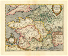
Detailed Ortelius Map of France in Roman Times, Based on Classical Sources
Vivid map of Ancient France from Ortelius' Parergon, the first historical atlas. The map is based upon information from classical sources such as Strabo, Virgil, Ovid and Caesar.
It differs from Ortelius' similar Galliae Vetus map (here) in that it is based upon ancient geographical sources, rather than ancient military sources, making it substantially more detailed.
Oriented northward, this map displays Ancient France, from its border with Spain (Hispaniae pars) in the southwest to Great Britain (Britanniae pars) in the northwest. The map also stretches east to Germany (Germaniae Magnae pars) and Italy (Italiae Gallicae pars). The country is divided into four main provinces, which make up this area of the Roman Empire: Belgica, Celtica Lugdunensis, Narbonensis, and Aquitanica.
This map is characterized by excellent attention to detail. The shape of the coastline is fairly accurate, which is unsurprising given that Europe was well mapped by Ortelius’ time. Rivers are carefully rendered, and throughout the map mountain ranges and forests give the land texture. In particular, the Pyrenees Mountains (Pyrenaei montes) dividing Spain and France and the Alps (Alpes) near Italy are notable. These details help to orient the viewer and give a sense of the physical geography of the land.
Cities are represented with miniature views, which is typical of Ortelius maps. Some may be recognizable to the casual viewer as well-known cities today, such as London (Londinum) in Great Britain, Geneva on Lake Geneva (Lemanus lacus), and Paris (Parisii) in north-central France.
Some water bodies such as the Mediterranean Sea (Mediterranei Maris pars) and the English Channel (Oceanus Britannicus) can be seen around the edges of the map. Filling them in with stippling gives the water a bit of texture without distracting from the many labels and locations on the map. A pair of decorative ships also sail the more northern waters.
Two beautiful cartouches adorn the map. In the southwest corner, the title cartouche is particularly ornate. It indicates the subject of the map, Ancient France (Galliae Veteris). A simpler cartouche in the northeast corner dedicates the map to two renowned noblemen, Lord Edward van der Delft and Carolus from Mechelen. These strapwork cartouches employ texture and shading which give them a vivid appearance. The title cartouche also includes figural elements, flora, and fauna.
Much of this map is based upon the geographical writings of classical scholars. Ortelius notes Strabo’s thoughts on the Venetian Islands (Veneticae insulae), where the Amnitae tribe women are excellent dancers. Pliny and Ptolemy are also cited as sources for a peninsula (Cervix Peninsulae) in the northwest.
Parergon
Although best known for his world atlas, the Theatrum Orbis Terrarum, the Parergon was a project of personal interest and the work that Ortelius himself considered his greatest achievement. He had a deep curiosity about classical antiquity which spurred him to create the Parergon maps, and the amount of time and detail he put into each map is clearly evident. Ortelius hand drew each map of the Parergon, which required considerable skill and knowledge of the area’s history and geography. It is considered the first historical atlas.
Parergon means supplementary and, accordingly, the first three Parergon maps were published as supplements to the 1579 edition of the Theatrum, which had already been in print for nine years. Over time, successive editions of the Theatrum were supplemented with more Parergon maps, and there are 55 known plates overall. The Parergon was also published as its own atlas separate from the Theatrum on two occasions, once in 1595 and again in 1624.
The Parergon was highly successful both as a supplement to the Theatrum and on its own. It was variously translated into French, German, Italian, and English and regularly printed until 1612. Further editions were more sporadic but still popular, such as the 1624 edition which was published twenty-six years after Ortelius’ death in 1598.
This intricate map is an exceptionally detailed depiction of Ancient France. It would be a valuable addition to a collection of French or European maps, Ortelius maps, or maps of classical antiquity.
Abraham Ortelius is perhaps the best known and most frequently collected of all sixteenth-century mapmakers. Ortelius started his career as a map colorist. In 1547 he entered the Antwerp guild of St Luke as afsetter van Karten. His early career was as a business man, and most of his journeys before 1560, were for commercial purposes. In 1560, while traveling with Gerard Mercator to Trier, Lorraine, and Poitiers, he seems to have been attracted, largely by Mercator’s influence, towards a career as a scientific geographer. From that point forward, he devoted himself to the compilation of his Theatrum Orbis Terrarum (Theatre of the World), which would become the first modern atlas.
In 1564 he completed his “mappemonde", an eight-sheet map of the world. The only extant copy of this great map is in the library of the University of Basel. Ortelius also published a map of Egypt in 1565, a plan of Brittenburg Castle on the coast of the Netherlands, and a map of Asia, prior to 1570.
On May 20, 1570, Ortelius’ Theatrum Orbis Terrarum first appeared in an edition of 70 maps. By the time of his death in 1598, a total of 25 editions were published including editions in Latin, Italian, German, French, and Dutch. Later editions would also be issued in Spanish and English by Ortelius’ successors, Vrients and Plantin, the former adding a number of maps to the atlas, the final edition of which was issued in 1612. Most of the maps in Ortelius' Theatrum were drawn from the works of a number of other mapmakers from around the world; a list of 87 authors is given by Ortelius himself
In 1573, Ortelius published seventeen supplementary maps under the title of Additamentum Theatri Orbis Terrarum. In 1575 he was appointed geographer to the king of Spain, Philip II, on the recommendation of Arias Montanus, who vouched for his orthodoxy (his family, as early as 1535, had fallen under suspicion of Protestantism). In 1578 he laid the basis of a critical treatment of ancient geography with his Synonymia geographica (issued by the Plantin press at Antwerp and republished as Thesaurus geographicus in 1596). In 1584 he issued his Nomenclator Ptolemaicus, a Parergon (a series of maps illustrating ancient history, sacred and secular). Late in life, he also aided Welser in his edition of the Peutinger Table (1598).
![[ Second World War-Italian Submarine Warfare ] Azione Del Sommergibili Italiani Negli Oceani 1940-1943 [Action of Italian Submarines in the Oceans 1940-1943]](https://storage.googleapis.com/raremaps/img/small/80832.jpg)
![Nova Rhaetiae atq[ue] totius Helvetiae descriptio per Aegidium Tschudum Glaronensem](https://storage.googleapis.com/raremaps/img/small/80319.jpg)

![[ Ski Trail Map for Davos Region ] Skitourenkarte Parsenn-Davos-Klosters](https://storage.googleapis.com/raremaps/img/small/91601.jpg)