|
||

|

|
|

|
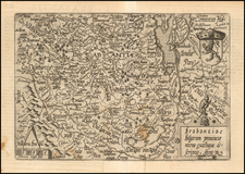
Rare Lafreri School Map of Flanders By Domenico Zenoi
One of the earliest obtainable maps of the Flanders region, first published In Venice in 1559.
The map is based upon Gerard Mercator's 4 sheet map of Flanders, first published in 1540. Zenoi follows the map of Michele Tremezzini, first published in Rome in 1555.
The map incorporates a 32 point compass and a number of coats of arms.
Among the more fascinating elements of this map is the inclusion of the 2 windmills found on Mercator's 4 sheet map (the Catstert windmill and the Scerpenberg windmill), plus the addition of two unnamed windmills located between the villages of Boeschepe and Godewaersvelde (now just over the Belgian-French border, in the vicinity of the Catsberg or Mont des Cats).
![Les Campemens des Armees du Roy dans les Pays-Bay depuis L'Annee 1690, jusques en 1695 dedies a sa Majeste . . . [The Camps of the King's Armies in the Netherlands from the year 1690, until 1695 dedicated to his Majesty. . .]](https://storage.googleapis.com/raremaps/img/small/87565.jpg)