|
||

|

|
|

|
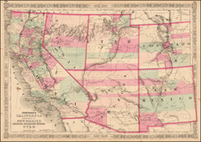
Rare Separately Published Thomspon & West Pocket Map of California & Nevada
Nice brightly colored example of Thompson & West's map of California and Nevada, which was issued in pocket format and in a few rare California County Atlases, was the first map of the two states to appear in an Atlas published west of the Mississippi River.
The map is one of the most detailed commercial atlas maps of the period, showing the counties and townships in better detail than its commercial counterparts. The print is also much larger than its commercial counterparts, making it much more readable.
Includes railroads, proposed railroads, county seats, towns, villages, mountains, rivers, islands, roads and a number of other early details. Minor fold split extends about 2 inches into the map. This is the third example of the map we have had in 16 years. An excellent map for California and Nevada collections.
![(San Diego -- WWI Panoramic Photograph) Camp Kearny. Co. M. 158th Infantry [World War I panoramic group portrait of U.S. Army Infantryman at Camp Kearny, San Diego]](https://storage.googleapis.com/raremaps/img/small/91707.jpg)