|
||

|

|
|

|
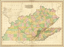
The First Map of Tennassee Printed Outside of America
Fine example of the rare London edition of Daniel Smith's map of Tennessee, published in London in 1795.
An excellent topographical map, showing settlements, trails, roads, Indian boundaries and Indian Towns.
This edition of the map appeared in A Topographical Description of the Western Territory of North America. . . , by Gilbert Imlay, published in London in 1795. Imlay's map is based upon a map first advertised in conjunction with Mathew Carey's publication of Daniel Smith's A Short Description of the Tennassee Government… in 1793, but which was not issued in that work and was first available as an insert to the work in January 1794.
The map includes wonderful annotations concerning the soil, grass, timber and other details of Western Tennessee, the south boundary of a military reservation, the Kentucky Road etc. The boundaries of 8 early counties are also noted. An essential map for Tennessee collectors.
The Imlay edition of this map is quite rare on the market, this being the first example we have seen on the market, without the complete book.
Daniel Smith was the son of Henry Smith and Sarah Ann Crosby. He attended the College of William and Mary in Williamsburg, Virginia.
After training to as surveyor at William and Mary, he moved to Augusta County, Virginia, where he served as deputy surveyor in 1773.
Smith first came to Middle Tennessee during the winter of 1779-1780, hired to survey the western region of the Virginia frontier, and particularly to chart the line dividing Virginia and North Carolina.
As a militia officer, Daniel Smith helped defend the Virginia frontier during Dunmore's War and the American Revolution. He became sheriff of Augusta County in 1780 and was commissioned a colonel in the Virginia militia, taking part in the later battles of the Revolutionary War, including Guilford Courthouse and Kings Mountain. On October 5, 1781, Smith was appointed "Assistant Deputy Surveyor" in the Southern Department of the Continental Army under Thomas Hutchins.
After the Revolution, he returned to the area, moving his family to a 3,140-acre tract on the Cumberland River in 1784. This land grant, from the state of North Carolina, was granted to him in payment for his work as a surveyor. In 1783 Daniel Smith was appointed county surveyor and justice of the peace in Davidson County (then part of North Carolina), where he helped survey the state military land grant reservation in the Cumberland Valley. One of five trustees to oversee the establishment of the City of Nashville, he was a charter trustee of Davidson Academy, the first institution of higher learning in Nashville. This school, founded in 1785, would be transformed into Cumberland College (1806), the University of Nashville (1826), the
Peabody Normal College at Nashville (1875), and finally the George Peabody College for Teachers, now part of Vanderbilt University.
Smith was prominent in local affairs and was appointed a brigadier general in the militia. He was a member of the 1789 North Carolina convention which voted to ratify the United States Constitution. . In 1790, he was appointed by President George Washington to serve as secretary of the Territory of the United States South of the River Ohio, with authority to act for the governor in his absence. The first map of the region, created from his surveys, was published in 1794. He held this post until the territory became the State of Tennessee in 1796. Smith was a member of the 1796 convention, chairing the committee that wrote the state’s first Constitution and Bill of Rights.
In the first decade of the 19th century, Smith was instrumental in negotiating several treaties with the Cherokees. He served several months of Andrew Jackson’s unexpired term in the U.S. Senate (Jackson had resigned to serve on the Tennessee Supreme Court), and was later elected to his own full term in the Senate from March 4, 1805 to March 31, 1809 when he resigned and returned to his Sumner County estate, Rock Castle in Hendersonville, pursuing his agricultural and business interests until his death.
Rock Castle State Historic Site is preserved today as an historical landmark and one of the early examples in Middle Tennessee of a plantation.
Smith County Tennessee is named for Daniel Smith.
The Daiel Smith Papers can be found in the Tennessee State Libarary and Archives. Daniel Smith’s surveying record book, listing property boundaries and naming many of the earliest settlers in Middle Tennessee, can be found in the Tennessee Historical Society collection THS-911.