|
||

|

|
|

|
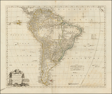
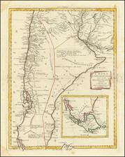
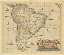
Sanson's 1656 double-page engraved map of Chili, from Peru to Patagonia and the Straits of Magellan. It is vertically centered on the Andes Mountains, focusing on the river systems, lakes and coastal features of Chili.
The map is based upon Alonso de Ovalle's large map of Chile, published in Rome in 1646. De Ovalle, author of Historica Relacion del Reyno de Chile (Rome 1646) was born in Chile in 1601. De Ovalle was born to an elite Buenos Aires family but elected to join the Society of Jesus in 1617. He became a successful missionary and rector of the "Colegio Seminario." He remained active among the Chilean Indians until 1641, when he traveled first to Spain and then Italy, where he remained until 1650, during which time he wrote his seminal work on the history of Chile.
Nicholas Sanson (1600-1667) is considered the father of French cartography in its golden age from the mid-seventeenth century to the mid-eighteenth. Over the course of his career he produced over 300 maps; they are known for their clean style and extensive research. Sanson was largely responsible for beginning the shift of cartographic production and excellence from Amsterdam to Paris in the later-seventeenth century.
Sanson was born in Abbeville in Picardy. He made his first map at age twenty, a wall map of ancient Gaul. Upon moving to Paris, he gained the attention of Cardinal Richelieu, who made an introduction of Sanson to King Louis XIII. This led to Sanson's tutoring of the king and the granting of the title ingenieur-geographe du roi.
His success can be chalked up to his geographic and research skills, but also to his partnership with Pierre Mariette. Early in his career, Sanson worked primarily with the publisher Melchior Tavernier. Mariette purchased Tavernier’s business in 1644. Sanson worked with Mariette until 1657, when the latter died. Mariette’s son, also Pierre, helped to publish the Cartes générales de toutes les parties du monde (1658), Sanson' atlas and the first French world atlas.