The item illustrated and described below is sold, but we
have another example in stock. To view the example which
is currently being offered for sale, click the
"View Details" button below.


|
||

|

|
|

|
Stock# 50378
Description
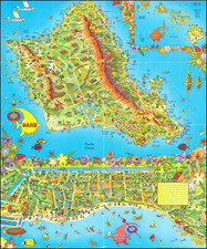
Early map of the City of Honolulu, extending from Kalihi Channel and Fort Shafter in the West to Kahala Beach and Waialae to the east, centered on Waikiki and the Punch Bowl.
The map provides significant detail throughout, including beaches, government installations, buildings, schools, roads, etc.
Large maps of Oahu and statistical and tourist information on the verso.
Condition Description
Minor soiling
![[Waikiki] Waikiki Photo-Guide Map](https://storage.googleapis.com/raremaps/img/small/87465.jpg)