|
||

|

|
|

|
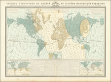
A Wall of Icebergs Surrounding the Antarctic -- World Map Dedicated to the King of Sardinia
This is a rare set of maps depicting the world on a Polar Projection and a Mercator's Projection by Salvador Lirelli, dedicated to the King of Sardinia and approved by the Royal Academy of Science of Turin.
After the title, Lirelli explains that he made this map to offer readers a new perspective on the world. This is achieved through the dual-projection of the earth presented in three parts. In the memoir placed between the hemispheres, Lirelli explains the choice to include both projections. The Mercator Projection at the bottom is excellent for calculating distance for navigation, but it is not as reliable at high latitudes. For those Polar Regions, a Polar Projection is superior, hence his inclusion of both so that the reader can jump between the two for a more accurate understanding of the globe.
The title is cordoned off from the maps by thick braid held by an eagle. The double hemispheres of the Polar Projection are arrayed below the title, with the northern hemisphere on the left and the southern on the right. The southern hemisphere is particularly intriguing as there is no Antarctica, for it was still unknown to navigators and geographers. Instead, Lirelli has hypothesized that the pole is surrounded by mountains of ice, a guess not far from the truth of the cold continent.
Ranged below the two hemispheres is the world on a Mercator projection. The poles have been removed, with latitude ranging only to 45° N and S. On both projections, the dates of European land encounters are marked. New Holland is still connected to Van Dieman's Land, as this map was made before Flinders' second voyage, but New Guinea and New Holland are no longer hypothesized to connect, separated instead by the Endeavour Strait. On both the southern hemisphere map and the Mercator Projection, New Zealand is remarkably accurate.
The influence of Captain Cook
Both the Endeavour Strait and the precision with which New Zealand is drawn are thanks to the voyages of Captain Cook. The tracks of his ships are traced on all three maps, giving the reader a deeper appreciation for just how far Cook and his crews sailed over the course of a decade.
His first voyage (1766-71), shown here in black, was in the Endeavour, hence the name of the Strait. The voyage was supposed to observe the Transit of Venus from the South Seas. Cook observed the Transit at Tahiti and went around New Zealand and to Botany Bay.
The second voyage (1772-5), in red, took Cook in the Resolution and the Adventure around the Cape of Good Hope and into the high southern latitudes of the Indian and Pacific Oceans in search of the supposed Great Southern Continent. It was on this voyage that Cook ruled out the geographic chimera definitively.
The third voyage (1776-80), in blue, sought another long-lost geographic hope, the Northwest Passage. Cook set out around the Cape of Good Hope again, landed at New Zealand, then struck out north, encountering Hawaii on the way. Cook then led his ships, Resolution and Discovery, to the far north of the Pacific, charting the coastlines of the Pacific Northwest. Then the ships returned to Hawaii, where Cook was killed in an altercation with the indigenous peoples. His crew continued on their journey, returning north and then sailing along the East Asian coast and home around the Cape of Good Hope.
The influence of Lirelli's map
According to the Memoires de l'Academie Royale des Sciences de Turin, Lirelli presented a manuscript version of this work to the Society for review. The academicians were impressed, complementing the way it made map reading easy due to the close-up view of the usually hard-to-see Polar Regions. They granted the map their approval and named Lirelli a geographe du roi.
The Academie in Turin was part of Italy's resurgence in the sciences in the late eighteenth century. Enlightenment ideas had reached northern Italy in the 1740s, helped by the election of a progressive Pope, Benedict XIV. In 1757, the Turin academic Cesare Beccaria began a scientific society with some of his students. It was first called the Societas Privata Taurinensis but was later renamed the Societe Royale des Sciences. Victor-Amadeus, the King of Sardinia, was the Society's patron, hence the dedication of Lirelli's map. The King made the Society official in 1783, just three years before this map was made, and the name changed again to the Academie Royale des Sciences. The Society still exists today, under the name Accademia delle Scienze di Torino.
Lirelli worked in Novara, and became director of the observatory in Turin in 1791. He was born in 1751 and died in 1811. The 1780s were an active period for him, as he also published a geographic analysis meant to accompany a new atlas of Europe in 1789.
The map is rare, with only two institutional listings on OCLC (British Museum, Biblioteca Nacional de España) and additional copies at the Biblioteca Nazionale (Italy), Biblioteca Casanatense (Italy) and Univerzity Karlovy (Czech Republic). The British Library's copy is referenced in the King George Collection catalog of 1829.
Memoires de Academie Royale des Sciences: Annees MDCCLXXXVIII-LXXXIX (Turin: Jean-Michel Briolo, 1790), XCI-XCII.
Catalogue of Maps, Prints, Drawings, etc. Forming the Geographical and Topographical Collection Attached to the Library of His Late Majesty King George the Third, and Presented by His Majesty King George the Fourth to the British Museum (London: Trustees of the British Museum, 1829), 365.
The Turin Society: http://eulerarchive.maa.org/historica/places/turin.html
Lirelli worked in Novara, and became director of the observatory in Turin in 1791. He was born in 1751 and died in 1811. The 1780s were an active period for him, as he also published a geographic analysis meant to accompany a new atlas of Europe in 1789.
![[ Wright- Molyneux Map ] [ New mapp of the world according to Mr. Edward Wright commonly called Mercator's projection ]](https://storage.googleapis.com/raremaps/img/small/99967.jpg)