This item has been sold, but you can enter your email address to be notified if another example becomes available.


|
||

|

|
|

|
Stock# 50227
Description
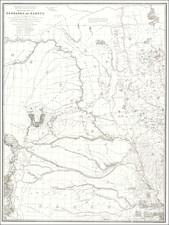
Detailed map of the Des Moines River and a short section of the Mississippi River, by David Dale Owen, with detailed Geological observations below.
Along the Mississippi River, the primary towns shown are:
- Ft. Madison, Iowa
- Nauvou, Illinois
- Nashville, Iowa
- Charleston, Iowa
- Montrose Iowa
- Keokuk Iowa
- Warsaw, Illinois
- Nassau, Iowa
- Alexandria Iowa.
Along the Des Moines River, the pimary towns (in Iowa) shown are:
- Fort Des Moines
- Dudley
- Lafayette
- Bennington
- Red Rock,
- Knoxville
- Amsterdam
- Eddyville
- Ottumwa
- Iowaville
- Portland
- Philadelphia
- PIttsburg
- Keosauqua
- Bentonsport
- Bonaparte
- Farmington
- St. Francisville
Other towns in Iowa, north of the Des Moines, include
- Libertyville
- Birnmingham
- Winchester
- Dalonega
- Agency
- Oskallosa
- Pella
Without question, the most detailed map of the Des Moines River from this period which is reasonably obtainable by collectors.