
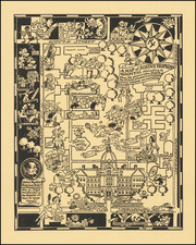
![[ Baltimore ] Map of the City and Suburbs of Baltimore Compiled from Actual Surveys 1853 . . . By Isaac Simmons / William Sides](https://storage.googleapis.com/raremaps/img/small/102136.jpg)


|
||

|

|
|

|
Rare separately published map of Baltimore, prepared by Williams Sides and published in Baltimore by Isaac Simmons.
The map is exceptionally detailed. Hand colored by wards, it shows towns, major buildings, parks, railroad lines, wharfs, and other places. Outside of the main town grid, the map becomes a finely executed cadastral map, naming property owners and showing roads, towns, and other buildings and other features in remarkable detail.
The Branches of the Patapsco River are shown, with detailed sounding given and Line of Quarantine, which was established in the 1840s due to repeated outbreaks of small pox, yellow fever and typhus. Sides also published A Map of the Medical Topography of Baltimore in 1851.
This is one of the earliest maps issued by William Sides and Isaac Stevens, who also re-issued Thomas Poppleton's monumental wall map of Baltimore in 1851.
The map is very rare on the market. We locate only the examples in the Newberry Library and Johns Hopkins University.
![[Includes Mail Road Timetable and Prices] Map of a Reconnaissance between Baltimore and Philadelphia Exhibiting the Several Routes of the Mail-Road Contemplated by the Resolution of Congress Approved on the 4th of May 1826](https://storage.googleapis.com/raremaps/img/small/82583.jpg)