The item illustrated and described below is sold, but we
have another example in stock. To view the example which
is currently being offered for sale, click the
"View Details" button below.


|
||

|

|
|

|
Stock# 50100
Description
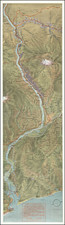
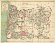
The Most Detailed Map of Oregon Published in the 1880s
Scarce and highly detailed general land office map of Oregon, tracking the growth of the State.
The map highlights to growth expansion of formal settlements of Indian Tribes in the State, the expansion of the township surveys and growing knowledge of topographical features east of the Cascade Mountains.
Includes tremendous topographical and geographical detail, including up to date state surveys, Indian and Military Resevations, early railroad lines, post offices, forts, towns, rivers, roads, lakes, mountains, etc.
Perhaps the best large format map of Oregon of the period.