


|
||

|

|
|

|
Striking survey and land title history of Hacienda de Nuestra Se ñ ora de Guadalupe del Carnicero and plan of Socavón de la Purisima Concepción silver mine in San Luis Potosi
The brilliantly colored surveys are included with 25 pages of text, bound in a soft leather folio, providing an extensive file detailing the sale of a portion of an hacienda. Together, the documents offer a rare microhistory of the region at the beginning of the nineteenth century. The map is combined with a very unusual mining survey map on the verso.
To see the survey of the mine, see /gallery/detail/50057a
The documents
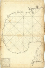
The first document is a strikingly decorative yet geometric land survey signed by surveyor Pedro Ignacio de Alardin. The polygon of the land in question is drawn in vivid color, with illustrations at each node of plants or buildings. The compass rose inside the polygon reveals the survey to be oriented north. Around both the scale and the entire survey there is a delicately drawn and brightly colored border. To understand the origin of this survey, it is necessary to follow the 47 pages of text that accompany the document.
In 1801, brothers Don Juan Nicolas and Don Francisco Mata sought to sell a portion of their Hacienda, Nuestra Señora de Guadalupe del Carnicero, to two fellow vecinos, or neighbors, of Real de Catorce, Don José Alejandro Aguilar and Don José Francisco Rangél. The brothers had bought the land from Capitán Don Ramon Saballos. The land up for sale consisted of seven plots that together formed the area measured in the survey.
In colonial New Spain, surveys were most often used as legal tools to settle land disputes or, in this case, to clarify a land deal. Before the sale could be finalized, Tomás de Anteparalureta, the Subdelegado del partido, an official akin to a magistrate, ordered the land surveyed in accordance with the wishes of the parties involved. Subdelegados were created in 1786 to replace the role of corregidores; both positions carried out civil and legal duties in the Spanish empire.
Over the course of several days in early February 1801, Pedro Alejandro Aguilar carried out his survey. He measured the land, accompanied by the sellers and the buyers. The final product was the colorful plan discussed above and the testimony of Aguilar. The surveyor explained that the deal accorded with the titles and existing documents relating to the property. In his testimony, Aguilar explains each mohonera, or landmark, its location, distance from the next landmark, and records the assent of both buyers and both sellers as to his activities. An abbreviated form of these remarks are in the key in the lower right corner of the survey. This narration of the process used to survey is a rare glimpse into this occupation's craft and it is therefore of considerable historical value.
Acting on the recommendation of the surveyor, the subdelegado approved the sale. It was finalized on the 9th of February in a document that makes up the last fifteen pages of the text. The sale came with the proviso that none of Don Francisco Mata's children from his first wife, who had claim on the Hacienda, would inherit this portion of land being sold. In addition, Aguilar and Rangél were to be able to use and profit from all the amenities and improvements on the land and, if revalued at a later date, the Mata brothers could not demand more money than the seven thousand pesos they had agreed upon.
These stipulations did not sour the deal and all signed it, with the exception of Don Francisco Mata, who could not write. His assent was recorded via the signature of a witness, Miguel Guzman. Other witnesses who signed included Don José Maria Aguirre, Don Luis de España, José Mariano Godines, and José Francisco Ramirez. The scribe, who made the original documents and then copied them for Aguilar and Rangél on February 12, 1801, was José Felix Nuño.
At the end of the approval of sale and the finalization of sale there are identical added notes. These date from 1827 and explain that Don Francisco Rangél gave Doña Manuela, the sister of Aguilar, one thousand pesos as a pension. The witness to this proceeding was one Mariano Godines, perhaps the same Mariano Godines who had also acted as witness 26 years previously.
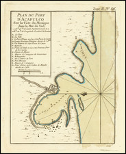
There is one more document in this grouping, another survey, this time of a silver mine, the Socavón de la Purisima Concepción. It is signed, in a delicate oval cartouche of bowed branches, by José Salvador Antonio de la Puente, and dedicated to Aguilar. It is dated 1814, thirteen years after the first survey.
The colorful plan shows the entire mine, including its subterranean portions. The entrance is marked by the number 1, in the buildings toward the south of the plan. The letter Z, and a gold circle ringed by a red one indicates the mine shaft, which connects to the tunnels below. The tunnel network snakes to the northwest. Some tunnels, like E, have proven rich. Others, like C and D, remain unknown, or desconocida. All the depths of the tunnels are labeled in the detailed explanation, in an oval at the left of the beautifully decorated plan.
Silver country
The proceedings for this deal and both surveys were completed in Real de Catorce, a town in the modern state of San Luis Potosí. The Spanish found silver and gold deposits in the area in 1561, triggering a massive metal rush. The Potosi part of the name comes from the silver mines already operating in Bolivia, an aspirational comparison that was never fully realized. The Mata brothers are listed as owning the Hacienda and a mina de plata, or a silver mine.
Real de Catorce derives its name from the Royal Fourteen, fourteen Spanish soldiers killed in an ambush by Chichimeca warriors. The settlement sprang up in 1772, when silver was discovered nearby. The Mata silver mine was likely part of this vein of the metal. The Socavón de Purisima Concepción was also one of the mines borne of the Real de Catorce boom. The bonanza was short lived, however, as production slowed considerably during the War of Independence, just when the Socavón plan was made.
English investment supported a revival in the mid-nineteenth century. Purísima was the first mine in Mexico to use dynamite, in 1873. By the end of the century, the rush was over as the price of silver dropped dramatically in 1900. The mine continued some operations into the twentieth century. Today, visitors still can see the chimney of the mine, along with various buildings that are partially in ruins.
Officially founded in 1779, Real de Catorce's parish church was still being constructed when the Matas sold their land to Aguilar and Rangél. By the late nineteenth century, 15,000 people lived in the town. It had a mint and a bull ring, but its fortunes rapidly diminished along with the price of silver. Today, the town is used as a ghost town in movies like "The Treasure of the Sierra Madre," "The Mexican," and "Bandidas." It is also a pilgrimage site for those seeking the image of Saint Francis of Assisi in the parish church. It is one of the designated Pueblos Magicos, villages with charm that are highlighted for tourists.
More local still, there is still a small village at Guadalupe del Carnicero, the remains of the Hacienda concerned in this case. It is located roughly halfway between Real Catorce and Charcas.
Taken as a group, these surveys and documents offer a fascinating and very rare view into the legal and economic practices of San Luis Potosí during one of its many booms. They enrich our knowledge about Real de Catorce considerably and should be considered historical treasures.
Full text of 50057:
Mapa Geográfica y Descripción Geométrica de la División y corte que se executó de las Tierras de la Hacienda de N. Sra. de Guadalupe del Carnicero correspondiente a los Senóres Dn Juan Nicolas,y Dn Francisco Mata de Venta, que hicieron a los Señores Dn José Alexandro Aguilar, y Dn José Francisco Rangél. Cuya Ares es como se sigue:
- Mohonera del Mesquile(¿) de Santa Rosa Punta fixo, de donde se hizo el corte o División sobre el rumbo del Poniente con 37 grados de inclinación al sur correspondiendo á la Mohonera Esquina B.
- Mohonera Punto fixo que corresponde a la Letra A. y es la dicha B. Esquina del Lindero de la Hacienda de Laxas, y Sierra Hermosa
- Meza de Leandro
- Tanque(¿) de Reta
- Cerrito de Castañon y Punto donde termina los Linderos de Sierra Hermosa
- Sastrecillos
- Punta de las Lomas de los Sastrecillos y Punto donde comienzan los Linderos del Rancho de los Coronados
- Rancho de San Christobal
- Mesquile de Santa Rosa, y Punto donde terminan los Linderos del Rancho de los Coronados
Cuya Potencia comprende toda esta Área setenta y ocho mil doscientos ochenta y siete cordeles quadrados, que hacen siete sitios, tres quartos y un pedazo de Tierra de setecientos ochenta y siete cordeles quadrados. Cuya División se concluyó en Esta Hacienda de Sor San Miguel a cinco días del mes de Febrero del mil ochocientos y un años
Pedro Ignacio de Alardín
Full text of 50057a:
Explicación.
- Punto donde debe comenzar el Socabon que debe constar de 1.3ol vs 38.C. su dirección S. 25 P.
- 1ª. Ven que corta este a las 74 v. 98c. de profundidad Es trasversal. Su ancho 1 ½ v su rumbo N. 22 P. con dos catas en buenas pintas.
- 2ª Veta que se corta a 154 v 51C. de profundidad su rumbo 0.5.N. Es desconocida.
- 3ª id…id. a 163 v 86 c. de id. Su rumbo P. 43 N. Desconocida.
- 4ª id…id a 184 v 46c de id. Su ancho 1 ½ v. su rumbo S. 22. O.
- 5ª id…mui ancha y corrida, que corra el Socabon a la profundidad de 204 v. 97c. Su rumbo P.30. N. Tubo razonables frutos en la Mina de la Olla.
- 6ª id…conocida paz de Dacal, que se corta a las 267 v. 12 c de profundidad. Su ancho 1 ½ vs. Su rumbo O. 27. S.
- 7ª id…de la Luz, en actual bonanza, que debe cortarse a las 290 vs. 35 C. de profundiad. Su rumbo O. 22.S.
Y. 8ª id…de la Mina de Rayas que debe cortarse a las 359 v 67c. de p. su rumbo O.22.N.
Z. Tiro subterraneo para cortar la Veta de Purisima a las 270v. abaxo de sus planes actuales.
Q.Q. Vera de S. Jose de Reyes y 5 Señores. Ultima que debe cortar el Socabon a las 412 v. 68C. de profundidad. Su rumbo O. 22 ½ N.
1. Voca de la Mina de la Pma.
2. Tiro exterior de id.
3. Tiro interior de id.
4. Labor de Baitasar en buenos frutos en agua.
5. Testera introducida en lietras(¿) de Valenciana.
6. Leabor de Pma. introducida en tierras de S. José de Reyes en frutos con agua.
7. 8. Cuchilla que resultó entre esta y la Mina de la Cara Valenciana
9. 10. 11. 12. Pertenencia de la Mina S. Jose de Reyes que consta de 200 v. a hi lo de Veta y 100v. de quadra.
13. 14. 15. 16. Pertenencia de la Mina de 5. Señores que consia de la misma mensura con la diferencia de que esta cubrió su Veta con jov/s.
17. 18. 19. Cuchilia que corresponde a la Mina de Pina.
Lower right corner:
Lo hizo José Salvador Ant/o de la Puente y lo dedica al Sr. D. Alexandro Aguilar Rl. de Catorce Mayo 28 de 1814.
http://www.sgm.gob.mx/pdfs/SAN_LUIS_POTOSI.pdf

![(Humboldt Atlas and Text) Geographique et Physique du Royaume de Nouvelle-Espagne [with quarto text:] Essai Politique de la Royaume de la Nouvelle-Espagne](https://storage.googleapis.com/raremaps/img/small/99796.jpg)
![(California-Mexico Border Survey) Datos de los trabajos astronómicos y topográficos. [bound with:] Variedades de la civilizacion, nueva epoca (Tomo I)](https://storage.googleapis.com/raremaps/img/small/70777.jpg)