|
||

|

|
|

|
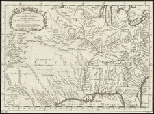
Rare Map of the Buffalo Trace or Vincennes Trace, as Recorded By A French Spy Plotting The Retaking of Louisiana By France -- The First Printed Map of Any American Road West of the Appalachian Mountains
Rare map of the Buffalo or Vincennes Trace, the primary overland route in the region during the later part of the 18th Century. The map shows a route from the Ohio River at Limestone (now Marysville, Kentucky) to Frankfurt on the Kentucky River, via Lexington and the Old Fort. Approximately 15 towns are shown along the way. Because of its importance as the major overland route in the region, Collot reconnoitered and mapped the route during his spy mission, the only overland route which for which Collot felt a separate map was justified.
The map is oriented with south at the top, and follows perhaps the most famous route through the region during the 18th Century. This is, without question, the earliest printed map to focus on the Buffalo Trace and the earliest printed map of any road west of the Appalachian and Alleghany Mountains.
Collot and Jean Baptiste Truteau explored the Mississippi and Missouri between 1794 and 1796. The work was completed in 1804, but delayed 20 years by the death of Collot. The work represented a significant step forward in the mapping of the regions explored. This is one of 23 maps which appeared in the Atlas volume, of which only 100 were printed in English. The work is of extreme rarity and very important in the history of American Cartography.
The Buffalo or Vincennes Trace
The Buffalo or Vincennes Trace was a major route running through what are now the American states of Kentucky, Indiana, and Illinois. Originally formed by millions of migrating bison, the Trace crossed the Ohio River near the Falls of the Ohio and continued northwest to the Wabash River, near present-day Vincennes, before it crossed to what became known as Illinois. This buffalo migration route, often 12 to 20 feet wide in places, was well known and used by American Indians. Later European traders and American settlers learned of it, and many used it as an early land route to travel west into Indiana and Illinois. It is considered the most important route to the Illinois country.
After the American Revolutionary War, in the late 1780s the U.S. government granted land in New York, Ohio and Indiana to veterans as payment for service. One of the major land recipients in the region was George Rogers Clark, who led the Illinois campaign against the British during the Revolutionary War. The land granted to Clark became known as Clark's Grant. George Rogers Clark used the Trace to return to the Louisville area after his Illinois Campaign.
As the Continentals took control of the Illinois country during the Revolutionary War, the Trace became a busy overland route, which made it a target for Indian war parties. Clark's memoirs mentioned the Trace in describing an early Indian attack on traders in 1779, after Hamilton surrendered at Fort Sackville and Clark's militia controlled Vincennes.
Several written accounts by explorers, the military, and settlers document the Trace's use as an overland route. In 1785 and 1786 explorer John Filson travelled by river to Vincennes and returned to the Falls of the Ohio via the Trace; he documented his travels along the road. Filson's overland route took nine days. By the time of Collot's arrival, it was, without question, the most important overland route in the region and the primary path of settlers entering the region, which is likely the reason for Collot's survey of the road.
Overview of Collot's Spy Mission, Report & Maps
Acting under instructions from Citizen Adet, French Minister to the United States, General George Henri Victor Collot undertook a secret reconnaissance in 1796, of the western American frontier. Collot traveled from Pittsburgh down the Ohio to the Mississippi, up the Mississippi to the Missouri and Illinois Rivers, and then back down the Mississippi to New Orleans. During his journey, he constructed a large number of exceptionally detailed manuscript maps and views of the region that he traversed. Many of these were groundbreaking, containing never before recorded information about a wilderness that was just beginning to undergo settlement.
Completed at nearly the exact time that Lewis & Clark were departing St. Louis, up the Missouri River, Collot's maps were engraved in Paris in 1804, but publication was suppressed due to Napoleon's sale of Louisiana to the United States the previous year. The Louisiana Purchase effectively ended any possibility that the region could be acquired by France. As a result of the changing politics and Collot's death, his report and maps did not come to market until 1826, when they were issued in a limited number under the title Voyage dans l'Amerique Septentrionale . . .
A nineteenth-century bookseller called Collot's work "one of the most famous, most important, and rarest of all books of Mid-Western Explorations." Eberstadt pronounced it "extraordinarily rare." Its rarity is due to the supposed deliberate destruction of all but three hundred French and one hundred English copies by the publisher, who had purchased the edition from Collot's estate, hoping to increase its value.
The Supression of Collot's Report & Maps
Following his return to France, Collot set out to prepare his report and maps from notes and sketches taken during his journey. In 1800, Napoleon acquired Louisiana from Spain, Collot, and Adet were named two of the commissioners of the new French territory. However, before they could cross the Atlantic to take up their assignments, Napoleon had a change of heart and decided to sell Louisiana to the United States.
Napoleon Bonaparte's decision to sell Lousiana to America brought a practical end to Collot's work on behalf of the French Government. As a result, the impetus to publish Collot's work disappeared and, to the contrary, it became expedient to supress his reconaissance, rather than publish its results and overtly admit to the Americans the full scope and extent of Collot's espionage work during his visit.
Ironically, the supression of Collot's maps has a simultaneous parallel during Thomas Jefferson's administration, when 4 expeditions were sent out by Jefferson to explore the Louisiana Purchase and the Transmississippi West (Lewis & Clark, Zebullon Pike, Dunbar-Hunter and Freeman-Custis expeditions). In April 1806, Thomas Freeman, surveyor, and Dr. Peter Custis, naturalist, undertook an expedition at the request of Thomas Jefferson's administration through parts of Arkansas, Louisiana, Texas, and Oklahoma. They were accompanied by a military escort under the command of Capt. Richard Sparks. At the same time that Zebullon Pike was exploring westward into the Louisiana Territory, Freeman and Custis traveled along the Red River to a site in present-day Texas in the vicinity of the old Caddo villages, where they were stopped by a force of Spanish cavalry protecting the Spanish claims to an ill-defined boundary of the Louisiana Purchase. After a brief skirmish, Freeman and Custis withdrew.
While a report of the 1806 Freeman-Custis expedition was published and a map prepared by Nicholas King, the political sensitivity surrounding the expedition was such that the report of this southern expedition into Texas was kept secret, with only a few copies printed. Nicholas King's map of the expedition, which provided physical proof of the US Government's encroachments into Spanish Texas, was supressed completely, with no known examples of the map surviving until an example was discovered in about 1877 in the Custis papers and a second example was discovered in the past decade, which had been owned by another early American explorer, Washington Hood (1808-1840).
Georges Henri Victor Collot (1750-1805) was a French soldier, explorer, colonial official, and spy. He served in France’s possessions in North America and the Caribbean. Born in Chalons-sur-Marne in northeastern France in 1750, the young Georges joined the army. He quickly ascended the ranks.
Collot’s first American experience was as a French officer fighting alongside General George Washington in the Revolutionary War. He served as aide-de-camp and maréchal des logis under French general Rochambeau.
From 1792-4, now a Major General, Collot was Governor of Guadeloupe. His time in the Caribbean was short-lived, however, as the British invaded the French colony, imprisoned Collot, and sent him to New York. He evaded punishment and the French turned his presence to their advantage.
Collot was ordered on a reconnaissance mission on the Ohio and Mississippi Rivers. He was to assess the military capacity and fortifications of their imperial rivals, Spain and Britain, as well as to report on the expansion of the Americans westward.
In the spring of 1796, Collot set out. He navigated southward through Illinois and Upper and Lower Louisiana, drawing detailed maps and plans along the way. His presence was not a secret, however; the English, Americans, and Spanish all issued orders to halt his progress. Collot was arrested at Fort Massac on the Ohio River by the American officer Zebulon Pike, but released when Pike found no legal basis for holding him. After reaching the Mississippi, Collot turned upriver to St. Louis, and explored short distances up the Illinois and Missouri rivers as well. While in St. Louis, he may have had access to the maps of the known course of the Missouri River, of Pierre Antoine Soulard, whose maps would later be utilized by Lewis & Clark, as well as access to information from Jean Baptiste Truteau, whose expedition up the Missouri River had just been completed in June 1796.
When Collot arrived in New Orleans in October of 1796, the Spanish Governor, Carondelet, seized Collot and his maps. He was released in early December and returned to France.
Changing imperial politics delayed the publication of Collot’s account of his voyage until 1805. He died in the same year. At the time of his death, his spy mission was little known. It was only in 1826 that a limited reissue of his account was published by Arthus Bertrand. He printed 300 French copies and 100 English; Bertrand destroyed the surviving 1805 examples.
Collot’s maps and plans are superbly rendered cartographic works detailing the contested Mississippi and Ohio River Valleys and they remain very scarce today.


![La Florida [with] Guastecan [with] Peruviae Avriferae Regionis Typus](https://storage.googleapis.com/raremaps/img/small/89451.jpg)
![(Upper Louisiana / Missouri) [Manuscript document: an agreement to sell a keel boat between Abner McCourtnay and Hubbard & Hertich, both of Sainte Genevieve, Territory of Upper Louisiana, 9 April 1812] Memorandum of an agreement...](https://storage.googleapis.com/raremaps/img/small/96184.jpg)