|
||

|

|
|

|
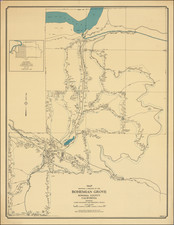
The First "Official Map" of San Bernardino County
Rare large format map of the Southwest portion of San Bernardino County, prepared by T.D. Beasley, in 1891 and photo-lithographed by Britton & Rey, in San Francisco.
Important early map of a portion of San Bernardino County, issued 1 year prior to T.D. Beasley's Official Map of San Bernardino County. The map is referenced in A California State Mining Bureau publication entitled: A Bibliography Relating To The Geology, Paleontology, and Mineral Resources of California (1904) at page 226, which lists the map as the earliest large scale printed map of San Bernardino County.
The map includes a notation at the bottom right, indicating that the San Bernardino County Board of Supervisors adopted the map as the Official Map of the County for the portions shown on October 6, 1891.
This remarkable map extends from the Holcombe Valley Mining Districts and the Big Bear Lake Area (then called Bear Valley Reservoir) in the northeast, to Banning and the Morongo Indian Reservation (unnamed), in the southeast. In the south, the map extends to cover the Temescal Valley, south of Corona, in what is now Riverside County. In the west, the map extends to the Chino Hills and Ontario, with Mount Cucamonga and Mt. San Antonio shown in the north.
The map is a remarkable amalgam of modern subdivisions and transporation lines, super-imposed over a detailed topographical map of the region, with significant irrigation information included.
Numerous early citrus and other irrigation districts are noted, including:
- Citrus Belt Irrigation District
- Ontario Colony Lands
- Riverside Land & Irrigation Company
- East Riverside Irrigation District
- Rialto Irrigation District
- Grapeland Irrigation District
- Semi Tropic Land And Water Cos. Lands
While the majority of the area is surveyed, several large swaths of land in the eastern part of the map are still denoted as Unsurveyed Lands.
Coming at the tail end of Southern California's first major real estate boom (and bust), many of the towns noted did not exist only a few years prior to the preparation of this map and a number towns listed have long since disappeared, including:
- Urbita
- Sansevaine
- Rochester
- Irvington
- Bairdstown
- Alessandro
- Victoria
- La Drew
- Mount City
- Messina
The map is of the utmost rarity, with no known appearances on the market at auction or in dealer catalogs. We locate only 3 examples of this map (Bancroft, California State University at San Bernardino and University of Michigan).
![[ Baja California / Gulf of California ] Carta Esferica de las Costas y Golfo De Californias Llamado Mar De Cortes Que Comprende desde el Cabo Corrientes hasta el Puerto de San Diego Construida …. 1825](https://storage.googleapis.com/raremaps/img/small/102732.jpg)