|
||

|

|
|

|
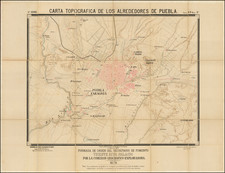
Map of Texcoco district showing the now-dry Mexico Valley Lake System and revealing the institutionalization of mapping in the new nation
This is a map of Texcoco, now in the modern state of Mexico and then a district of that state. The map shows facets of a nascent Mexican style of mapping and is especially interesting for its use of the Meridiano de México.
The map shows political borders with thick red lines. Texcoco is land-locked except for the large lakes on its eastern border. A key in the lower left corner reveals this area to still be heavily agricultural in the mid-nineteenth century; it highlights local towns, estates, ranches, and smaller farms. It also designates the district capital, Texcoco, and the municipal seats, like Ozumba and Totolapa. The settlements are clustered in the west and north of the district. This is due to the higher elevation of the east, where the volcanoes of Telapon, Ixtaccihuatl, and Popocatepetl are marked.
Institutional mapping in Mexico
In the top right, a title proclaims this map to be taken from the general, referring to the carta general made by a Commission of Statistics. This is the Commission of Military Statistics, as will be explained below. The map was copied by a state employee, Rafael Santiago de la Sierra, who purportedly finished it in 1848. In the bottom right, a note explains that this edition is reduced by half from the original. The reduction was done with the permission of the Prefect, a Señor Carrasco.
Running along the bottom of the map is a secondary title in Latin. It explains that this is a reproduction completed by Paul Primer, surveyor and member of the Mexican Society of Geography and Statistics, in the deceiving date 1842. Primer's dedication also mentions Ignacio M. Altamirano, who is described as a friend of all indigenous peoples and their descendants. Both the name of the society and Altamirano point to a later date for this reproduction.
The Mexican Society of Geography and Statistics was founded in 1833 as the National Institute of Geography and Statistics. Its mandate was to promote and facilitate the mapping of the new nation and was the first geographical society established in the Americas. As such, its operations were supported by both liberals and conservatives and received funding despite the political upheavals that defined Mexican politics in this period.
In 1839, the Institute was renamed as the Commission of Military Statistics, the commission referenced in the title. Part of the Ministry of War, the employees of the commission now received a federal salary, hence Santiago de la Sierra's claim of being an "empleado del estado." The Commission was tasked with the creation of a carta general, a master map of the entire nation to be kept in a centralized repository, a practice taken from the Spanish. It was from these "master" materials that this copy was made.
The mind behind a national map was Pedro García Conde, an army officer. Conde joined the newly-formed Corps of Engineers in 1828, where he worked on topographical surveys, including one of Mexico City. In 1837, now a colonel, he returned to the city to head the Military Academy. In the early 1840s, as a general, Conde worked on a national map of Mexico, sending out questionnaires and accessing geographic materials in archives. However, politics and pending conflict with the United States prevented him from publishing in Mexico, a story you can read here: /gallery/detail/15146%3Fview%3Dprint . In 1848, Conde would be named as Mexican Boundary Commissioner, tasked with overseeing the setting of the boundary between the United States and Mexico.
In 1849, just after the first copy of this map was made, the Commission of Military Statistics became the Mexican Society of Geography and Statistics, the name it carries today. The Society reviewed all existing maps. It also released new publications, including an 1850 carta general that showed the recent territorial losses to the United States in the Treaty of Guadalupe-Hidalgo, the product of Conde's Boundary Commission.
Based on the dates of these name changes, it is not possible that this reproduction was made in 1842. Close examination of that date reveals that the 4 is written over another number, most likely an 8. It is most likely an 8 because Ignacio Manuel Altamirano, mentioned in the dedication, was president of the Society from 1881 to 1889.
Altamirano (1834-1893) was a Mexican writer, journalist, teacher, and politician. Born in Guerrero, he was the son of Nahua parents, hence the mention of his support of indigenous peoples. Besides serving as President of the Society, Altamirano also founded several newspapers, was a magistrate and President of the Supreme Court, and authored numerous books.
The various titles and inscriptions preserved on this map therefore reveal the history of the institutionalization of cartography in Mexico. From its earliest decades the nation was concerned with mapping its regions and boundaries. The institution itself went through several name changes, which allows us to more accurately date this reproduction of a reduction of a portion of the carta general. Each twist in its production represents another layer of Mexican history and cartography.
An emergent Mexican style
Not only is this document a unique manifestation of Mexican cartographic history, it also reveals a Mexican style of mapping. The striking font is singular and is now associated with Mexico and the American West. Another noteworthy addition that makes this map distinctly Mexican is the use of the Meridiano de Mexico as the prime meridian. This meridian bisects the Federal District but does not match the larger grid of latitude and longitude used to draw the map.
In 1884, two years after this copy was made, an international conference decided upon Greenwich as the source of the Prime Meridian. Prior to this time, various prime meridians were in use, with those passing through Greenwich, Paris, and the Cape Verde Islands as the most common. The use of Mexico as its own prime meridian, or at least a national meridian, is rare to see.
Texcoco
Whereas the Meridiano de Mexico passes through the capital, this map is focused on Texcoco. Texcoco's history owes much to its important location. The district, as shown on the map, borders Mexico D. F., the state of Puebla, the then territory and now state of Tlaxcala, the then district and now municipality of the state of Hidalgo Tulancingo, and the then district and now municipality in the state of Morelos Cuernavaca. Located in the Valley of Mexico, the city of Texcoco was prominent in several Mesoamerican societies. Many rulers made Texcoco their homes, including Nezahualcoyotl, one of the founders of the Aztec Triple Alliance.
Cortés and the conquistadores arrived in 1519 and it was here that the Spanish built the brigantines which were used to attack Tenochtitlan. Initially, Texcoco was the second city of New Spain, but its importance faded with the centuries. From 1827 to 1830 it was the second capital of Mexico State, but that designation was then moved to San Agustín de las Cuevas, known today as Tlalpan. In 1837, the city was made the seat of the district of the same name, as seen on this map.
The missing and mythic geographic features of Texcoco
The main lakes within the borders of Texcoco are Laguna Texcoco and Laguna Chalco. The former was a natural lake. Agriculture near the lake began 7,000 years ago with several early civilizations competing to control access and farming near its shores. After the fall of Teotihuacan in 600-800 AD, several other city states fought for prominence in the region. In 1325 the Aztecs founded Tenochtitlan on the western side of the lake, developing their capital city on an island via a system of dams and canals. This city became the Federal District. After the Spanish took Tenochtitlan, they never repaired the dams, making flooding a recurring problem in the region. To stem the floods, the Spanish attempted to drain the lake, but drainage was not entirely successful until the mid-twentieth century.
The other lake within the borders of the district of Texcoco is Lake Chalco. An important activity in Lake Chalco was farming on chinampas, artificial islands located on shallow lake beds. Lake Chalco, like all the lakes shown here, is smaller than in centuries past. In 1519, when the Spanish came, the lakes of Zumpango, Xaltocan, Texcoco, Xochimilco, and Chalco were all connected. As this mid-nineteenth century map shows, the drainage had largely separated and diminished the lakes. Today, the lakes are all but gone and the sprawl of urban centers, especially Mexico D. F., has taken over the area. Thus, this map shows geographic features important to the history of Mesoamerica that have now disappeared.
A geographic feature labeled on this map that is still recognizable today is Iztaccíhuatl, or Ixtaccíhuatl as it is written on the map in the Nahua style. Iztaccíhuatl is a dormant volcano, the nation's third highest peak. Popocatépetl, also labeled on the map, to the south of Iztaccíhuatl, is the second highest. Another shorter volcano, Telapon.
Iztaccíhuatl is Nahuatl for "white woman", a name garnered from the four snowy peaks of the mountain that represent the woman's head, chest, knees, and feet. According to Aztec mythology, Iztaccíhuatl, a princess, fell for a warrior, Popocatépetl. Iztaccíhuatl's father sent the warrior to war in Oaxaca. He promised the brave fellow his daughter's hand, but only because he assumed the soldier would not return. When Popocatépetl did return, he found his beloved dead. She had been told her love died in battle and she then died of grief. Popocatépetl took Iztaccíhuatl's body to be buried outside Tenotitchitlan, where the gods changed their bodies into mountains and covered them with snow. Popocatépetl became an active volcano, exploding to reign fire on the ruler who tricked him. In fact, Popocatépetl remains Mexico's most active volcano. It has had fifteen major eruptions since the Spanish arrived in 1519, with the last major eruption in 1947. Smaller eruptions happen frequently.
Title in upper right: Mapa del Distrito de Texcoco sacado del general que levantó su Comision de estadistics, por Rafael S/go de la Sierra Empleado del Estado 1848.
Title and text across the bottom: Mapa Hanc Distriti Texcoco, Mandata Reproductio Ilustrissimi Juris Consulti
Ygnacio M. Altamirano
integerrimi amici omnium Indigenarum et Desensori eorum,
Atque Praesidenti Soc. Mex. Geog. & Stat.
Officiose et Humiliter Dedicat Paulus Primer, Agrimensor et Sócius hujus Societatis. Mexico. Idus Oct. A. 1842.
Above left of dedication: Mandó sacarlo el Sr. Prefecto Joaquin Noriega y es propiedad del Distrito. Rafael Santiago de la Sierra.
Above right of dedication: Reducido á la mitad del Original. Con permiso del Sr. Prefecto Carrasco.
![Map of Mexico, Central America, and the West Indies [Insets of Bermuda, Sandwich Islands, Jamaica and Panama Railroad]](https://storage.googleapis.com/raremaps/img/small/78369.jpg)
![[Campeche]. Plano del Estado de Campeche 1861. Formado en la Agencia del Ministerio de Fomento en Campeche con vista en su mayor parte de los datos Topográficos é* hidrográficos reunidos por ella y otros datos y noticias que se tuvieron presentes por H. Fremont.](https://storage.googleapis.com/raremaps/img/small/68167.jpg)