This item has been sold, but you can enter your email address to be notified if another example becomes available.


|
||

|

|
|

|
Stock# 49514
Description
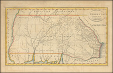
Early Appearance of the American Flag On A Printed Map
Rare map of the Southeastern United States, which appeared in Gordon's History of the Rise of the United States.
The map shows Georgia, Virginia, and North Carolina extending to the Mississippi River.
Many early forts are noted along the Mississippi River and are shown. A number of early western counties are shown in Western Virginia, including Lincoln, Neilson, Jefferson ,Fayetter, Mercer, Maddison and others.
The Cumberland Settlements are noted. Many early roads shown.
Excellent detail throughout East and West Florida.
The Boundaries between the United States and the Spanish Territories are noted, as are the Indian Boundaries.
Condition Description
Repaired tear, extending through the word ocean at the right center.
Reference
Wheat & Brun 495.
![[Los Angeles Olympic] O Limp Hicks Loose Anglaise Calif. 1932](https://storage.googleapis.com/raremaps/img/small/90509.jpg)
![[HAPAG Map of the United States and Canada]](https://storage.googleapis.com/raremaps/img/small/78779.jpg)