


|
||

|

|
|

|
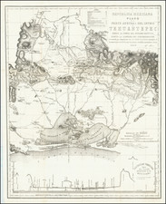
Manuscript Road Rap of part of Puebla, Mexico
This is a road map of an area in the modern state of Puebla.
The sketch is south-oriented, as indicated by the decorative suns labeled "sur" and "norte" at the top and bottom of the page. To the south, a mountain range intersects with the road. To the east, a large cerro, or hill, sits next to an estancia, or estate. This estate has served as the " centro de la merced", or the center of a land grant from the Crown.
Roads are indicated by two parallel lines and are labeled with their origin and destination. They radiate from Tecamachalco, situated to the north at the bottom of the page. The road running west to east originates in Tepeaca.
Tecamachalco was originally founded in 1441 by Popolocas, a tributary group to the Aztecs. The Spanish came in the 1520s and construction of the church and convent were finished by 1530.
Tepeaca was conquered by the Aztecs in 1446 and renamed by Hernán Cortés, the Spanish conquistador, as Villa de Segura de la Frontera in 1520. In 1542, the town passed into the control of the Franciscans, who built a monastery dedicated to St. Francis of Assisi. During the sixteenth and seventeenth century Tepeaca acted as the seat of a province, but under the Bourbon Reforms of the eighteenth century it was converted to a jurisdiction within the Intendancy of Puebla. It is still in the state of Puebla today.
![[ Earliest Obtainable Map of San Diego Bay ] Plan du Port De St. Diego en Californie. . . 1782 [with] Plan Du Port et du Departement de San Blas . . . 1777](https://storage.googleapis.com/raremaps/img/small/90982.jpg)