|
||

|

|
|

|
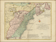
One of the Earliest Obtainable Maps of the United States in Fine Original Color
Fine old color example of Samuel Dunn's scarce map of the United States, one of the earliest obtainable maps to reference the name United States in English.
This map reflects the changed situation for the British government in relation to its former colonies after the war. The western boundaries of most of the states are left open, reflecting the conflicting claims as to whether they extended to the Mississippi River or the Pacific Ocean. Florida was depicted as the Spanish provinces of East and West Florida, while Louisiana, then a Spanish possession, dominates ther region west of the Mississippi.
In the upper left corner is a table which lists the lands of the United States, including the thirteen original states, Vermont and all the Lands between the Lakes, the Apalaches and the Missisipi and three British dominions, Territories of the Hudson Bay Company, Province of Quebec and Canada, and Newfoundland.
Notes within the map area show many Indian tribal lands and closes any argument for a northwest passage. An interesting early map of the United States.
Robert Sayer (ca. 1724-1794) was a prominent London map publisher. Robert’s father was a lawyer, but his older brother married Mary Overton, the widow of prominent mapmaker Philip Overton and the proprietor of his shop after his death. Mary continued the business for roughly a year after her marriage and then, in early 1748, it passed to Robert. Robert became a freeman of the Stationers’ Company later that year; his first advertisement as an independent publisher was released in December.
Sayer benefited from Overton’s considerable stock, which included the plates of John Senex. In the 1750s, Sayer specialized in design books and topographical prints, as well as comic mezzotints. In 1753, he, along with John Roque, published a new edition of Thomas Read’s Small British Atlas, the first of several county atlases that Sayer would publish.
Sayer’s business continued to grow. In 1760 he moved further down Fleet Street to larger premises at 53 Fleet Street. In 1766, he acquired Thomas Jefferys’ stock when the latter went bankrupt. In 1774, he entered into a partnership with John Bennett, his former apprentice. The pair specialized in American atlases, based on the work of Jefferys. They also began publishing navigational charts in the 1780s and quickly became the largest supplier of British charts in the trade.
Bennett’s mental health declined, and the partnership ended in 1784. As Sayer aged, he relied on his employees Robert Laurie and James Whittle, who eventually succeeded him. He spent more and more time at his house in Richmond. In 1794, he died in Bath.
![[Uncut promotional broadsides for ] Map of the Surface-Feeding Ducks, Swans and Geese of North America](https://storage.googleapis.com/raremaps/img/small/92052.jpg)
![[United States] Index Map](https://storage.googleapis.com/raremaps/img/small/67626.jpg)