|
||

|

|
|

|
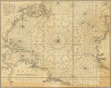
With Hand Drawn Tracks Showing Use at Sea in the Caribbean Trade and To South America
Rare Blue Backed Chart of the Atlantic Ocean, published by Blachford & Imray in London.
The present chart, covering the north Atlantic, was issued in 1847 as a "New Edition," although we can find no other examples of this or any other edition of the chart by Blachford or otherwise. Within a few years, Blachford & Imray were offering a different chart of the North Atlantic, covering roughly the same area, but extending a bit further south.
Includes a large inset map of Bermuda, profile view of the approach to New York Harbor and other profile views (Cape Verde and Finistere) and plans of the Road of Funcha and Channel between Fayal and Pico.
Perhaps the only surviving example of this chart.
Robert and William Blachford, based on Robert's earlier work, built a successful chartmaking business at the Navigational Warehouse, based in the Minories. Robert and William retired around 1835; they passed the business to Michael Blachford. Michael, in turn, partnered with James Imray and their business was successful. Imray bought Blachford out in 1846, continuing to grow his business into one of the most successful of the nineteenth century.

![Oceani Occidentalis Seu Terrae Novae Tabula [The Admiral's Map]](https://storage.googleapis.com/raremaps/img/small/102935.jpg)