|
||

|

|
|

|
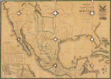
Adam Onis Treaty Era Map of North & South America
Fine pair of case maps of North and South America, with original slip case, published by Brue.
The map of North America was issued shortly after the publication of Lewis & Clark's map, with revisions to 1819. The map provides excellent detail along the Lewis & Clark Route. For the Rocky Mountains, the map relies primarily on information from Humboldt and Pike, pre-dating by several years the results of the Stephen Long Expedition to the Rocky Mountains.
Alaska is Russian America, with the map providing a still largely speculative coastline north of the Aleutian Islands and along the Arctic Coastline, with the coastlines known to Hearn and Alexander MacKenzie, providing the primary source information on the Arctic Coast.
The map was issued in April 1819, which had been signed on February 22, 1819.
The map of South America reflects the state of the continent during its several decades of struggle for indendence under the Revolutionary leadership of Simon Bolivar and others.
Andre Hubert Brué was a French geographer and cartographer. Born in Paris, he served in the French Navy, joining the Baudin expedition to the Pacific (1800-1804). After his sea service, Brué applied his navigation and charting skills to creating finely-crafted maps, which were renowned for their crisp engraving and accuracy. He drew directly on the copper of the plate, creating what he called encyprotypes. He is best known for the Atlas universal de géographie physique, politique, ancienne et moderne.
![A Geographical Chart: or, A Scheme, Comprehending The Most Important Particulars Relative To The Geography of North and South-America. : Designed to be an Auxiliary to the Student. Carefully Compiled from the Best authorities, by Amos Bingham [Copy-Right Secured]](https://storage.googleapis.com/raremaps/img/small/41406.jpg)