


|
||

|

|
|

|
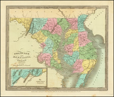
Rare example of the first edition of David Burr's map of Maryland and Delaware, which appeared in his Universal Atlas, first issued in 1836.
Shows counties, towns, rivers, roads, courthouses and other details.
Burr's Atlas was perhaps the most elegant American commercially published atlas of its time, utilizing wonderful wash colors and elegant engraving style. Burr studied under Simeon DeWitt in New York. His first atlas was an Atlas of New York State, the second state atlas to be issued in the US (after Mills Atlas of South Carolina in 1826). In the 1830s, he served as topographer for the US Post Office, producing a series of rare and highly sought after large format state maps during this period. Later, he was appointed as the Geographer of the House of Representatives, where he served during the later part of the 1830s.
Burr is widely regarded as one of the most important names in American Cartographic history.
David H. Burr studied law, passing the New York Bar Exam, and then surveying under Simeon DeWitt in New York. His first atlas was an atlas of New York State (1829), the second state atlas to be issued in the US (after Mills’ Atlas of South Carolina in 1826). In the 1830s, he served as the official topographer for the US Post Office, producing a series of rare and highly sought-after large-format state maps. He also created a map of the country’s postal routes, which features roads, canals, and railroads. Burr traveled to London to work with John Arrowsmith; together, they produced the American Atlas in 1839.
Upon his return to the States, Burr was appointed as a draftsman for the House of Representatives, where he worked until ca. 1841. He later worked for the Louisiana Survey and the Florida Survey. By 1850, he was back in Washington D. C., working on the census. In 1852, the Senate named Burr as the draftsman to compile maps from the Federal Surveys. In 1853, Burr traveled to San Francisco, perhaps as part of his work for the Senate. He was then named as the Surveyor General of Utah in 1855. However, he was unpopular there and returned to Washington D. C. by 1870. Burr is widely regarded as one of the most important names in the nineteenth-century American history of cartography.
![Carte Qui Contient La Maniere Dont Se Fait La Chasse Des Bouefs Sauvages . . . [Buffalo, Niagara Falls, Calumet Village, Huron & Illinois Indians]](https://storage.googleapis.com/raremaps/img/small/93146.jpg)
![(18th-Century Southern Borderlands) [Collection of manuscript letters to Secretary of War James McHenry from confidential U.S. agent John McKee, relating to southern borderlands, Native Americans and Panton, Leslie & Co.; a letter from John McKee written from Mobile, Alabama, to William Blount of Blount's Conspiracy fame; a letter from William Panton concerning John McKee; and letters from Felix D. St. Hilaire, concerning General Victor Collot]](https://storage.googleapis.com/raremaps/img/small/90005.jpg)
