|
||

|

|
|

|
One of the Earliest Decorative Wall Maps to Show Captain James Cook's Discovery of Hawaii
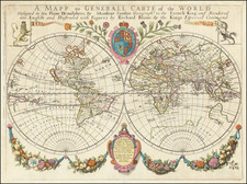
Easily one of the most decorative maps to be published in the second half of the eighteenth century, the Clouet/Mondhare was engraved by Jean Baptiste Louis Clouet and published by Louis Joseph Mondhare, in Paris. This is the second edition, augmented from the first edition of 1767. It is both a display item and an accurate depiction of the world as it was known in the 1780s.
At first look, the messages of the map seem mixed: precise, updated geography framed by biblical scenes and classical imagery. In reality, it is a distillation of the intellectual environment of the middle and upper classes of the time. One had to know of religion, history, geography, and natural philosophy (science), in order to confront the world that was expanding with every ship that came back from voyages round the world.
These voyages are featured prominently on the map, criss-crossing the double hemisphere projection. They offer a history of exploration over the previous two centuries, including the routes of Magellan, Mendaña, Tasman, Le Maire, Halley, Bougainville, and, of course, Cook. One of the most recent discoveries recorded on the map are the Sandwich Islands, or Hawaii. It was known by 1785 that Cook had perished there, making the islands of considerable interest to Europeans.
While the map is as up to date as possible, it also shows many of the geographic uncertainties that remained. For example, there is a Mar de l'Ouest (Sea of the West) in the Pacific Northwest, a French invention from the mid-eighteenth century. California is no longer an island, but New Holland is connected to New Guinea via Carpentaria. This was a common misconception, although it is curiously also connected to Terre Australe du S. Esprit, the exaggerated land promoted by Quiros, in the early seventeenth century. More conjecture lies in the extreme north, where Alaska takes on a curious shape, as only the outline of the southern coast was well known to Europeans at this time. The delineation and extent of Alaska was a topic of hot debate between mapmakers of the time; the subject inspired a forty year debate between the De L'Isle family of mapmakers, Thomas Jefferys and the Russian Academy, that was coming to a head just as this map was published.
Surrounding the map are twenty biblical vignettes, all from the Old Testament. They proceed in chronological order from the upper left corner in clockwise fashion. Between this religious border and the hemispheres, is a ring of eight astronomical diagrams, adding another layer of knowledge-astronomy-to this remarkable document. Augmenting the celestial element, between the double hemispheres is an armillary sphere, flanked by two Atlas-like men supporting the hemispheres. As a whole, it is a complex and quite handsome map, in unusually good condition for a wall map.
Jean-Baptiste Louis Clouet (1730-ca. 1790) was a mapmaker with premises in both Paris and Cadiz, which explains why the map is in both French and Spanish. He was eventually named Royal Geographer of the Academie des Sciences de Rouen. Although he made several lavish wall maps, he is best known for Geographie Moderne (1776-93).
Louis Joseph Mondhare (1734-99) was a native of Bougy, but he worked in Paris from 1759 until his death as an engraver, geographer, and print seller.
Jean-Baptiste Louis Clouet (1730-ca. 1790) was a mapmaker with premises in both Paris and Cadiz. He was eventually named Royal Geographer of the Academie des Sciences de Rouen. Although he made several lavish wall maps, he is best known for Geographie Moderne (1776-93).
![A General Atlas Containing Distinct Maps Of all the known Countries in the World. Constructed from the Latest Authority [Binder's title: Lucas's Cabinet Atlas]](https://storage.googleapis.com/raremaps/img/small/80266.jpg)
![[Volcanos and the Subterranean World] Tabula Geographico-Hydrographica Motus Oceani, Currentes, Abyssos, Montes Igniuomos In Universo Orbe Indicans, Notat Haec Fig. Abyssos Montes Vulcanios](https://storage.googleapis.com/raremaps/img/small/95720.jpg)