|
||

|

|
|

|
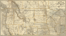
The Birth Certificate of Cheyenne -- The First Map to Show the Area Laid out for the City, but Pre-Dating its Establishment by Several Months.
Highly important manuscript map of the area around Cheyenne, Dakota Territory (now Wyoming), probably for the first time. The map, which comes from the collection of Union Pacific Railroad engineer Henry Harding, shows the area at the confluence of Crow Creek and Dry Creek in what would soon become the southeastern corner of Wyoming Territory.
Drawn shortly after General Grenville Dodge's vision for the line of the Union Pacific Railroad to run through the area which he crossed in September 1865, the map predates the official establishment, platting, and naming of the city, the establishment of the local fort, and indeed the actual arrival of the Union Pacific track, strongly suggesting that this is the fist map to show the future location of the City of Cheyenne and environs.
Furthermore, the map was quite likely drawn for Grenville Dodge himself, as he undertook the responsibilities of Chief Engineer of the Union Pacific and plotted and divided land on its way west.
Dating the Map
The map can be dated based upon the date of death of two of the men shown as owners on plots of land on the map. L. L. Hills (on the map "L. L. Hill") was killed by Arapaho indians on June 18, 1867. Percy T. Browne ("P. T. Browne") was shot by a band of Sioux warriors and died at LaClede Station also in June of 1867.
The map clearly blocks out the area to be occupied by the town of Cheyenne, but does not name the town, nor Fort David A. Russell, which was established on September 8, 1867. Furthermore the title of the map is "C. C. L. Co. D. T.", surely stands for Crow Creek, Laramie County, Dakota Territory. The fact that the name is not given as "Cheyenne" strongly suggests that the map predated the establishment of the town.
General Grenville Mellen Dodge & Thomas Clark Durant
Grenville Dodge (1831-1916) is a fascinating figure in the history of the Plains frontier; his origins as a Union soldier during the Civil War, and his subsequent transition from soldier, to surveyor, to corporate player, are quintessential in the narrative of the railroads and the west.
After his role in the Civil War (in which he, with the assistance of Thomas Clark Durant, smuggled Confederate cotton around Union blockades), Dodge commanded the U.S. Army's campaign against the Plains Indians. He maintained an extensive espionage network inside Native American camps, which, combined with his tenacity and military know-how, allowed him to prosecute an effective campaign.
In September of 1865, Dodge was on an expedition in the Black Hills when he came under fire from a Sioux war party. He led an escape down an uninterrupted ridge to the plains below, and in doing so discovered a piece of land with a suitable grade for a railroad. The problem of gaining elevation while traveling towards the Rocky Mountains had been a major thorn in the side of the Union Pacific, and Dodge would remark: "If we can save our scalps, I believe we've found a pass through which the Union Pacific can go."
Nine months later, in May 1866, Dodge resigned his post with the Army and took a job with the Union Pacific as chief engineer. Dodge had hoped to have, and some say was he was promised, complete control over the Platte River route of the Union Pacific. But that was not to be.
As chief engineer, Dodge was responsible for assessing the terrain and charting the Union Pacific's route across it. If he ran into an impediment, it was his job to overcome it. More importantly for the story of this map, Dodge led survey parties westward, and on these journeys he planted division points and divided the land into lots. When the main building crews followed behind, the land along the route sometimes coalesced as a town. These towns were often referred to as "Hell on Wheels" based on the violence and moral dissolution that followed.
Thomas Clark Durant (1820-1885), was always looking for an angle in business, and one such advantage he received was the accumulation of land along the route of the Union Pacific. But he was not alone in this, and, as the map illustrates so clearly, land giveaways along the route were commonly afforded to higher ranking employees of the Union Pacific.
Durant was keen to exert his influence over the project and imposed on Dodge a consulting engineer named Silas Seymour (named here as a landowner), whom Dodge would refer to as "the worst sneak I think I have ever met." The relationship between Durant and Dodge grew more contentious over the years. When Seymour's interference became too much, Dodge ignored him, drawing the ire of Durant, who sought to have his rival fired or forced to resign.
Durant himself was caught up in a financial scandal of his own making. Durant's personal financial vehicle, Credit Mobilier of America, had served him well in his efforts to surreptitiously take control of the Union Pacific and profit from its construction, but it had paid off many national politicians to facilitate business. When this was discovered, it caused major political repercussions, but the corporate malfeasance was largely legal at the time.
Owning Land next to the Union Pacific
One of the more important features of the map is how it lays bare the complex relationships within the Union Pacific and between the railroad and local Indians, and furthermore how these relationships were managed with land giveaways. The whole of the map around Cheyenne's footprint is given over to plots of land, the vast majority of which are owned by high-ranking employees of the Union Pacific.
William Bent and His Indian Sons
Perhaps the two best plots, just to the west of the would-be town, were owned by Dodge and Durant. However, a number of plots are also given over to the Bent family, foremost among them William Bent (1809-1869), the famed frontiersman and intermediary between the whites and Indians. William had long been a prominent businessman on the frontier and was one of the cofounder of Bent's Fort, which at one point was the largest building between Missouri and the Pacific. It seems that his relationship with the Union Pacific, and perhaps Dodge in particular, as well as the Railroad's desire to assuage the local Cheyenne, led to the plots being allotted to Bent and his family.
Bent's sons, George and Charles, were each given plots west of Cheyenne, across Crow Creek from the planned town. At the time, Bent's sons, Charles and George, along with other Cheyenne warriors, had been engaged in guerilla warfare against white settlers in general, including those laying out the railroad. George would give up that life to work as a translator for the U.S. government, while Charles would be killed by U.S. scouts and Pawnee two years after the map was made. Bent was increasingly becoming estranged from his two sons--the gift of land west of Cheyenne likely served the dual purposes of attempting to buy some peace with the local Cheyenne warriors and as a means of William Bent providing for sons with whom he was losing contact.
Others Named As Landowners On The Map
The map is interesting on so many levels -- it engages with the history of the American railroad at a pivotal time in its creation; it relates to many fascinating characters, and it is arguably one of the most important Wyoming maps to have come on the market in recent years.
Some of the landowners shown on the map who were related to the railway were:
- [J. M.] Eddy -- served with Dodge during the Civil War and part of the 1867 expedition wherein Dodge laid out the line to Cheyenne.F. M. Case, unit chief
- L. L. Hills, unit chief
- S[ilas A.] Seymour - consulting engineer
- P[ercy] T. Browne - Chief Engineer, who died in an Indian attack shortly before the map was prepared.
- M[arshall] F. Hurd - Dodge's staff engineer during the Civil War, who became a unit chief in what Dodge called some of the most difficult Indian Territory
- Ja[me]s A. Evans - division engineer
- J. E. House - Division Engineer in 1864. Future Chief Engineer of the UPRR, laid out townsites in Utah.
- O'Neil - assistant engineer
- W[ebster] Snyder - "One of the most difficult problems we had to solve was to keep sufficient material at the terminals to supply the daily demand. This work fell to Webster Snyder and his assistant, H. M. Hoxie, who had charge of the operation of the completed road." - Dodge, in How we Built the Union Pacific.
- S. B. Reed - unit chief
Provenance
This map comes from the collection of Henry Harding (1837-1910), a Union Pacific Railroad engineer from Hartland, VT. Harding was one of the landowners shown on the map at a plot just west of Cheyenne. He entered into Norwich University in Vermont, in 1852, where he met Grenville Dodge. Harding worked on eastern railroads until 1865 when Dodge hired him to work as an assistant engineer on the Union Pacific. Harding's specific responsibility was the architectural backbone of the road; he designed bridges, station houses, round houses, etc. He would go on to work for the United States Engineering Corps, 1873-1890. He retired in 1890 to his hometown of Hartland.
It is possible that Harding was the author of the map, he certainly possessed the requisite drafting skills, and he was close to Dodge, who was responsible for the early plotting shown here.
Rarity / Conclusion
The map is a unique survival, coming from the collection of Engineer Henry Harding, who almost certainly acquired the map at or about the time it was drawn. We are aware of no other examples of this manuscript map and no surviving documentary evidence that the map was previously known to scholars or collectors.
![[Report and] Map of an Exploring Expedition to The Rocky Mountains in the Years 1842 and to Oregon & North California in the Years 1843-44 By Brevet Capt. J. C. Fremont of the Corps of Topographical Engineers . . .](https://storage.googleapis.com/raremaps/img/small/88488.jpg)