|
||

|

|
|

|
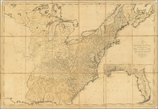
Previously Unknown Second State of the First Printed Map of The United States After The Treaty of Peace
The second state of the Wallis map of the United States, updated to show the the United States at the tail end of the War of 1812, published in London by John Wallis on October 1, 1814.
Published 29 years after the first state, the map has been updated to add Vermont, Ohio, Kentucky, "Tennaseee," and Western Territory. Main is now the District of Main and the name "Providence" no longer appears below Massachusetts Bay.
In addition to the printed revisions, the present map has been extensively annotated in an early hand, showing Chicago, Indiana, Michigan, Iowa, Kansas, Texas, Missouri, Arkansas, Mississippi and Alabama. The effort to update the map in manuscript is quite meticulous, seemingly showing the work of two different hands. The omisssion of Illinois is likely because of the use of listing of the Chiktachiks or Illinois Indian Tribe.
The imprint on this map is also of note, showing John Wallis (Senior) at 42 Skinner Street -- Snow Hill. As noted below, this is a very unusual imprint.
The Wallis Publishing Firm
John Wallis Sr. (died 1818) was an English board game publisher, bookseller, map/chart seller, print seller, music seller, and cartographer. With his sons John Wallis Jr. and Edward Wallis, he was one of the most prolific publishers of board games of the late 18th and early 19th centuries.
Wallis's company occupied a number of sites in London, England including:
- 16 Ludgate Street (under the name "Map Warehouse") from 1775.
- 13 Warwick Square (under the name "Instructive Toy Warehouse") from 1805.
- 42 Skinner Street, Snow Hill - this address was mainly used by Edward Wallis when working alone or when working with his father, in those cases publishing as "Wallis and Son" or "John & Edward Wallis".
- 188 The Strand - this address being used solely by John Wallis Jr.
Ashley Baynton Williams, a noted map and English printing history scholar, provides the following information:
- John Wallis Jr. was at 188 Strand from 1806 to 1808
- John Wallis Sr. was at 13 Warwick Square between 1805 and 1811.
Rarity
The map is unrecorded and prior to the discovery of this example, completely unknown to modern scholars.

![[First State of the Popple Key Sheet] A Map of the British Empire in America with the French and Spanish Settlements adjacent thereto by Hen. Popple.](https://storage.googleapis.com/raremaps/img/small/92714.jpg)