


|
||

|

|
|

|
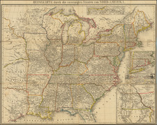
Rare Post-Louisiana Purchase / Pre-Lewis & Clark Map of North America
Rare map of North America, issued just 3 years after the Louisiana Purchase and including a fascinating look at the Northwest Pasage.
The map is noteworthy for a host or reasons. It provides a marvelous depiction of the vast unknown region beyond the known extent of the Missouri River, pre-dating the return of Lewis & Cark.
The depiction of the Northwest Coast of America and the northern parts of Alaska and the Northwest Passage are both meticulously detailed and unique in the shape of the coastline.
The map depicts signficant detail in Texas for the period. Georgia runs to the Mississippi River, as does a massive West Florida, on the eve of its purchase by the US from Great Britain.
There are a number of fascinating regions located, including Juinaer-Land (Illinois), Missurier-Land, Tschipiwaerland, etc. Fort Sinclair, Fort Detroit and Ft. St. Joseph appear in Michigan Territory, which is as yet unnamed. The place names in California are dominated by the Missions, but a few other place names are located. Excellent detail in Russian America. Perhaps the most noteworthy feature of tne map is the unique engraving style and elegant scroll lettering employed in the map.
The map is apparently very rare. This is the second example we have offered for sale in the past 20 years.

![[ First State of the First Map of America ] Novae Insulae XVII Nova Tabula](https://storage.googleapis.com/raremaps/img/small/94609.jpg)