|
||

|

|
|

|
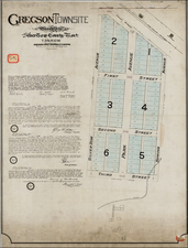
Rare Early Denver Map Showing Late Montclair and Richthofen 19th Century Subdivisions West of Downtown
Real estate map of the Monclair neighborhood in Denver, originally developed as a small suburban community east of Denver by Matthias P. Cochrane and Baron Walter von Richthofen, the latter a German nobleman and uncle to Manfred von Richthofen, the celebrated World War I flying ace known as the 'Red Baron'.
The map includes a fine image of the growing Denver Downtown area, with major buildings, street car lines and the City Park shown.
The Montclair community was originally designed to attract wealthier residents who were turned off by Denver's "400 saloons and forty Market Street bordellos." Promotional text notes the Art Museum Electric Line, Water and Electric Lights, Driveways, Streets and Schools.
Subdivisions in Montclair include:
- Richthofen's Montclair
- Porter and Raymond's Montclair
- Porter & Raymond's 2nd Addition to Montclair
The lots were being sold by Porter, Raymond & Co., and by Miller & Haekler.
Jarvis Hall Military School
The map locates Jarvis Hall Military School. Jarvis Hall was a Colorado liberal arts, grammar and military college from 1870-1904. Initiated in 1868 by Bishop George Maxwell Randall of the Protestant Episcopal Church and named after benefactor George A. Jarvis. This 1882-1904 site near Denver is part of the Lowry Airforce Base Campus. It is now part of a residential subdivision, centered on Crescent Park.
Denver Ladies College
The map locates "Denver Ladies College," an early name for "Colorado Woman's College." Conceived in 1886 by Reverend Robert Cameron of Denver's First Baptist Church. The organization was incorporated on November 14, 1888 as the Colorado Woman's College Society, with the idea of creating the Vassar of Colorado. The college would not formally open until 1909. The College was renamed Temple Buell College in 1967 and later to Colorado Women's College. In 1982, it was acquired by the University of Denver and operated at the original campus unitil 2001. The location is now home to Johnson & Wales University.
OCLC lists only a single example of this map, at Yale University.

![Nouvelle Carte Du Mexique, Du Texas Et D'Une Partie Des Etats Limitrophes . . . 1840 [Proposed Railroads In Texas -- First Appearance of Arizona on a Printed Map]](https://storage.googleapis.com/raremaps/img/small/103480.jpg)