|
||

|

|
|

|
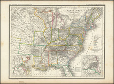
Freedom versus Slavery -- 1856 Republican Presidential Campaign Broadside Map -- Missouri Compromise.
Rare political broadside map, published in connection with the 1856 Presidential Election, with portraits of Republican candidates John Fremont and William Dayton and copious statistical details concerning the Free and Slave States. The map highlights what the Republicans believed to be the disproportionate control exercised by the Slave States over governance of the United States, the issue which had given rise to the party less than two years earlier.
This rare broadside reveals the importance of Kansas on the eve of the secession crisis, "drawing attention to the quantifiable measures of northern superiority: literacy rates, superior resources, and transportation networks. Yet, just as salient were the fears of Republicans--and northerners generally, that the future of the West was controlled by slaveowners." As Susan Schulten writes:
[A]ntislavery activist John Jay circulated a pamphlet on the eve of the election to demonstrate that a "small but iron-willed oligarchy" now ruled the South. Speaking in New York, Jay insisted that once Kansas was lost to slavery, the free states would "lose not only the Indian Territory lying to the south of it, but [also] those vast territories stretching to the westward." Nothing less than the nation's future, he insisted, turned on the 1856 election. Much of this campaign ephemera featured Kansas as the heart of the nation both politically and geographically-a symbol of the nation's greatest promise as well as its darkest failure. Consider . . . a . . . map published by George Colton-in a Republican campaign broadside issued by George W. Elliott in New York . Colton's map was used to highlight Kansas through color while dark lines boldly marked Frémont's expeditions across the West. This map used these expeditions to claim the land for the Republicans and connect the West to the party. Republicans intended to hang these broadsides in public places "wherever the people most do congregate." That the party chose to convey their message through maps is telling, for these images spoke to the widest possible audience, regardless of age or literacy. As Bloss wrote, "that which strikes the Eye lives long upon the mind."
In a late antebellum era of general border uncertainty and rapid territorial expansion by accession and annexation, maps such as the Elliott were vital in generating a visual image of the national form, depicting to Americans what the nation looked like, emphasizing a nation divided by slave interests.
Illustrating the Road to the Civil War
The Missouri Compromise of 1820 began a slew of stopgap solutions negotiated by the slave and free states in an attempt to balance their competing interests in the western territories. The Compromise regulated slavery in the western territories by prohibiting it north of the parallel 36°30' north (a demarcation carried over from the Royal Colonial Boundary of 1665). This boundary was sacred to the anti-slavery political outlook, and was embedded in the national debate about the future of slavery in the nation. The original agreement was put under repeated strain by new territorial acquisitions. The Mexican-American War gave rise to another temporary solution, the Compromise of 1850.
In 1854, Congress passed the Kansas-Nebraska Act, introducing the notion of "popular sovereignty" in the western territories. This made the question of slavery a matter for state-level decision making, and effectively opened lands north of the Missouri Compromise Line of 36°30' open to slavery.
This irrevocably upset the status quo in the West. The Whig Party did not withstand the ensuing turmoil. Northern Whigs reconstituted with other anti-slavery elements resulting in the end of the Second Party System and the birth of Republican Party in 1854. Southern Whigs joined the Democrats.
The Fremont-Dayton Ticket
John Fremont was the first candidate for President of the United States from the new anti-slavery Republican Party. He had gained considerable national fame through his exploits in the West during the 1840s. The map highlights his numerous expeditions through Kansas, to and from California, thus proclaiming his qualifications for the Presidency and his party's claims to the West. Fremont was often depicted alongside William Dayton on election broadsides and pamphlets, as here. The ephemeral nature of such election material -- which was tacked up or pasted in public places -- has rendered it incredibly rare today.
The election of 1856 was complicated by the participation of the Know-Nothing Party, and Fremont's campaign was hampered in the North by fears that a Republican win would mean the beginning of a civil war. In the end, the Democrat James Buchanan carried the election with 45% of the vote, while Fremont garnered only 33%. Millard Fillmore came in third, with 21%, running as the Know-Nothing candidate.
In 1857, President-elect Buchanan and the United States Supreme Court attempted to put the issue of slavery outside of the realm of political debate. Ruling in Dred Scott v. Sanford, the Court effectively nullified the Missouri Compromise and exacerbated the divisions that were already painfully obvious. The election of 1860, and the victory of Republican Abraham Lincoln, would give the final impetus to Southern Secession and augur the beginning of the Civil War.
Conclusion
The Elliott map is a prime example of the deployment of geographic information in political debate; in this case in the struggle against slavery. It is a handsome artifact of the early Republican Party, visually embodying the moral commitment that led to its founding. While other maps served similar purposes, attempting to rally the North in the anti-slavery effort, the Elliott is the largest, rarest, and most detailed.
The Elliott broadside is very rare. This is the only example we know of to come to market. We note only the Boston Public Library example in broadside form illustrated online.
Susan Schulte, Western Historical Quarterly, Vol. 44 No. 1 (Spring 2013), pp 34-35. Schulten & Romero, Reconstituting the Center of the United States. Western History Newsletter, p. 11.