|
||

|

|
|

|
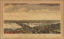
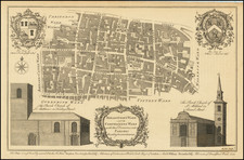
One of the Most Detailed Antiquarian Maps of Tudor London.
Fine large scale engraved view of London in 1560 "as it was near the begining [sic] of the reign of Queen Elizabeth." The map covers the cities of London and Westminster from the Tower of London in the east to Westminster Abbey in the west. South of the Thames River there are a number of landmarks of Tudor Southwark, including the bull and bear baiting pits and Winchester Palace. London Bridge is shown crossing the river into the City of London. Old St. Paul's Cathedral is depicted in its pre-fire state. The built up suburbs to the north only extend as far as Holborn and Spitalfields, although the hills of Hampstead and Highgate are notionally described in the background.
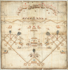
The "Woodcut" or Ralph Agas map of London.
The present map was based on a large 16th century view of London that Vertue attributed to the surveyor Ralph Agas (circa 1540 to 1621). Vertue's basis for this attribution came from an ambiguous quote in Oxonia Antiqua, Agas's map of Oxford from 1588. Later research has rendered this attribution dubious, as Agas only started work as surveyor in 1566, five years after this original map is understood to have been published, shortly after 1561. Vertue provided additional dating information in an integral text box:
These Buildings were not Erected when ye plan was taken
* The Whitehall Banquetting [sic] House ye 1st built of timber
* The Royal Exchange (not built) before 1570
* Moor Fields not divided nor planted
* Lambs Conduit on Snow Hill about 15
* Paget Place so called till the death of Lord Paget Ano. 1563
The "Woodcut" map was first published circa 1561, but it is now known in only three examples from a later edition of circa 1633.
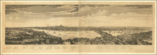
Relationship to the Braun and Hogenberg view of London
While the Vertue plan was based on the "Woodcut" map, Braun and Hogenberg's famed view of London was similarly based on another large scale and now-lost map of London, the "Copperplate" map. The "Woodcut" map is now understood to have been a close copy of the "Copperplate." The massive 15-plate map of London was probably published between 1553 and 1559, or based on surveys conducted in those years. It was unrecorded in modern times until one of the fifteen original engraved copperplates was rediscovered in 1962. Since then two additional plates have turned up.
As neither the "Copperrplate" map nor the "Woodcut" map are known in any 16th century original examples, the Vertue and the Braun and Hogenberg maps are among the only depictions of Tudor London still available to collectors.
George Vertue and the London Society of Antiquaries
George Vertue (1684-1756) was a prominent early 18th century engraver and antiquarian. His eclectic and artistic tastes drew him into the tastemaking circles in London during his time. He was a contemporary of William Hogarth and together they were members of the Rose and Crown Club. He was also the official engraver for the London Society of Antiquaries. The latter of which was a learned society "charged by its Royal Charter of 1751 with 'the encouragement, advancement and furtherance of the study and knowledge of the antiquities and history of this and other countries'."
As part of his responsibilities, he provided many of the illustrations for the Society's projects, foremost among these was Vetusta Monumenta, an series of publications documenting ancient buildings, arts, and artefacts. Additionally, Vertue undertook his project to re-engrave the "Woodcut" map under the aegis of the Antiquarian Society. This should come as no surprise, as the project was well within the interests of the Society.
In the 1730s and '40s Vertue showed a special interest in Tudor history and printmaking. This is obviously reflected in his copy of the "Woodcut" map. His interest can also be seen in the Historic Prints series of 1740, in which he imitated 16th century images of Henry VIII, Queen Elizabeth, and other royals. Much of his work for Vetusta Monumenta also revolves around Tudor architecture.