|
||

|

|
|

|
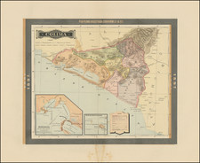
Detailed map of the Ures Mining District of Sonora, Mexico, drawn by L.H. Jansen, Mining Engineer.
The map shows the mining region which was then being actively promoted, primarily by American speculators, between 1900 and 1920. The region was promoted as being rich in Gold, Silver, Copper and Lead. The Ures, in particular, seems to have been best known for its Silver and Copper mines.
The maker of the map is shown as L.H. Jansen. Jansen was the President aned General Manager of the Sonora Chief Mining Company, which was incorporated in 1904 and 1905. Prior to Sonora, he was in Colorado in the 1880s and was apparently mining gold in the Kittitas County, Washington area in the 1890s. He was also later listed as the manager of the Llano Copper Company in 1907.
A "Proposed Rail Road" is shown, along with major mountains and the roads, in red, servicing most of the mines. Mines listed include:
- Sonora Chief Mining Co.
- Yaqui Copper Co.
- El Progresso
- Dividend
- Independence
- Sonora Queen
- Phoenix
- Gran Fortuna
- Dewet Placer
- Kreugar Placer
- Siglo Nuevo Placer
An interesting artifact of the boom period of mining in Sonora.
![[Hand Drawn Map] Le Golfe de Mexique avec les Pays Circonvoisins](https://storage.googleapis.com/raremaps/img/small/91580.jpg)