


|
||

|

|
|

|
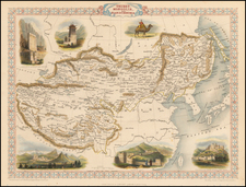
Detailed early map of China, based upon Du Halde's map of China, pubilshed circa 1736.
This attractive and geographically progressive depiction of China drawn by Haas from J.B.B. d'Anville's groundbreaking map of the Middle Kingdom.
The Qing Emperor Kangxi commissioned a ground of Jesuit surveyors to chart his kingdom from 1708 to 1716. The resulting maps were published as the Kangxi Atlas (1718-19), and the information contained on its woodcut maps would not be superseded for well over a century.
The leading French cartographer Jean-Baptiste Bourguignon D'Anville (1697-1782), acquired copies of the Kangxi maps and devised his own interpretations, first printed in Jean-Baptiste Du Halde's Description Geographique … de la Chine. D'Anville's atlas of China is the principal cartographic authority on China during the 18th century.
![The New Map and Street Directory of Shanghai City. Новый план города Шанхая с указателем улиц [Cover title] / The New Map and Street Directory of Shanghai City 最近實測上海地圖 [Zui jin shi ce Shanghai di tu]](https://storage.googleapis.com/raremaps/img/small/93141.jpg)
![[Gansu & Ningxia] Kansu](https://storage.googleapis.com/raremaps/img/small/61498.jpg)
![[ China ] Carte vom Reich China nach der neuesten grossen Carte des Herrn. d'Anville und Hase entworfen 1762](https://storage.googleapis.com/raremaps/img/small/103353.jpg)