


|
||

|

|
|

|
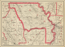
Early Railroad Map of Central California and Western Nevada
Rare separately issued promotional broadside, produced by S.G. Elliott, who would go on to have a colorful part in Californa and Oregon Railroad history.
Elliott's Broadside is a very early use of maps, views and statistical tables as a means of encouraging investment. The Broadside includes maps, views, and a large amount of statistical information covering everything from the number of votes in elections, to livestock and agricultural products, plus tables of distances, censuses of population, costs of building railroads. and more. Among the more interesting elements of this map are the extensive comparative tables, most of which focus on the 6 county region (Yuba, Sierra, Nevada, Placer, El Dorado and Sacramento), including population, agriculture, livestock, flower mills, saw mills, grain production, etc.
Published by G.W. Welch of Nevada City and lithographed by Britton & Co. in San Francisco, the Broadside is intended to promote railroad construction in Central California, but shows very interesting early details in Nevada, including the location of the Comstock Lode in the Washoe Mountains, Virginia City, Gold Hill, Silver City, Johnstown, Carson City, Genoa, etc. In a 1931 article on the Donner Party, W.W. Waggoner wrote:
In 1860 S.G. Elliott published a map of Central California for the purpose of promoting the Construction of Railroads. It gave not only the railroads completed and projected, but also the wagon roads connecting the various towns, together with statistical data, compiled by county assessors.
The main map extends from Solano County in the southwest to Virginia City in the northeast, Oroville in the northwest, Mokelumne Hill in the south, and all points within, including Lake Bigler (soon to be Lake Tahoe). The only completed railroad is from Sacramento to Folsom. The Sacramento, Placer and Nevada Railroad is projected to run from Folsom to Nevada City. The lines shown include:
- Folsom & Stockton Railroad
- Sacramento & Benecia Railroad
- Sacramento Valley Railroad
- Sacramento Placer & Nevada Railroad
- Benicia & Marysville Railroad
- California Central Railroad
- Oroville Railroad
- Central Pacific Railroad
The map also includes a map of Utah Territory, comprising the future Nevada Territory and inset views of:
- Auburn
- Folsom
- Grass Valley
- Sacramento
- Nevada City
The Broadside also shows compartive profile views of several important early roads through the Sierras to Nevada, including:
- Old Carson & Johnson Road
- Johnson's Cut-off Road
- Profile from Sacramento to Henness Pass
The map also provide topographical detail and an extensive accounting of the early roads in California. The initial survey for the Sacramento, Placer and Nevad Railroad was made by S.G.Elliott, the author of the map. From Nevada City, the railroad heading east is labeled the Central Pacific. Other proposed railroads are also shown.
The intent of the publisher would seem to have been the promotion of the region in the east.
S. G. Elliott was apparently quite active in early railroad promotion and road construction. He was the succesful bidder for the Lake Pass Turnpike Co. at Dutch Flat, to build a road to Steamboat Spring, and given a contract to build a road for $66,000, although no work was ever done. He appears later as a Director of the California & Oregon Railroad, as a dubious financing scheme. The Centennial History of Oregon, 1811-1912, Volume 1 at page 520-21 notes:
Mr. Elliott had been a county surveyor, and was a man of great energy, and ambition, but was not a civil engineer or constructor of railroads, and was not troubled with any scruples about plans or methods of business.
The view is extremely rare - OCLC locates only two copies, at the California State Library and the University of California, Berkeley.
Provenance: Warren Heckrotte, December 2015.
![(Texas - Spanish Colonial Era) [Manuscript document of 1692 concerning Bahia del Espiritu Santo on the Texas Gulf Coast, signed by the Viceroy's secretary, Juan Francisco de Vargas Manuel de Lodeña]](https://storage.googleapis.com/raremaps/img/small/95766.jpg)
![[Southwest Orange County] Corona Quadrangle](https://storage.googleapis.com/raremaps/img/small/83423.jpg)