|
||

|

|
|

|
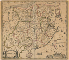
Decorative map of China, Japan, Korea and including the north portion of the Philippines, from Jansson's Novus Atlas.
The map depicts the eastern part of China (bounded in the west by the Great Wall), Korea as an island, and the three main islands of Japan.
The imaginary "Chiamay Lacus" is located in the southern part of the map, with numerous rivers flowing south into India and Siam. Striking cartouche flanked by Chinese figures, and an ornate scale of miles.
Shows European ships and Chinese sampans.
Jan Janssonius (also known as Johann or Jan Jansson or Janszoon) (1588-1664) was a renowned geographer and publisher of the seventeenth century, when the Dutch dominated map publishing in Europe. Born in Arnhem, Jan was first exposed to the trade via his father, who was also a bookseller and publisher. In 1612, Jan married the daughter of Jodocus Hondius, who was also a prominent mapmaker and seller. Jonssonius’ first maps date from 1616.
In the 1630s, Janssonius worked with his brother-in-law, Henricus Hondius. Their most successful venture was to reissue the Mercator-Hondius atlas. Jodocus Hondius had acquired the plates to the Mercator atlas, first published in 1595, and added 36 additional maps. After Hondius died in 1612, Henricus took over publication; Janssonius joined the venture in 1633. Eventually, the atlas was renamed the Atlas Novus and then the Atlas Major, by which time it had expanded to eleven volumes. Janssonius is also well known for his volume of English county maps, published in 1646.
Janssonius died in Amsterdam in 1664. His son-in-law, Johannes van Waesbergen, took over his business. Eventually, many of Janssonius’ plates were sold to Gerard Valck and Pieter Schenk, who added their names and continued to reissue the maps.