


|
||

|

|
|

|
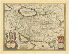
Fine old color example of Blaeu's map of the Kingdom of Persia, first published in Amsterdam in 1634.
The map shows the Persian Empire in the midst of the Safavid Dynasty, one of the most significant ruling dynasties of Persia (1501-1772). The Safavid Dynasty is often considered the beginning of modern Persian history. After the fall of the Sasanian Empire and the subsequent Muslim conquest of Persia in the seventh century A.D., the Safavid Dynasty came to power. The Safavid shahs ruled over one of the so-called gunpowder empires, a reference to their adaptation of gun powder in their arsenals (the Mughal and Ottoman Empires being the other gunpowder empires).
This map shows the Safavid Empire as it starts to decline in 1634, after the Golden Age of Shah Abbas. With the introduction of European trade during the time of Abbas, Iran had become partners with the English and the Dutch. With the Shah dead and no suitable heir, the Dutch East India Company, and later the British, used their superior maritime power to control trade routes in the western Indian Ocean. As a result, Iran was cut off from overseas links to East Africa, the Arabian Peninsula, and South Asia.
In addition to being cut off from these links, Iran fought their arch rivals: the Ottomans and the Uzbeks. Iran had to contend with the rise of Russian Muscovy, and in the far eastern territories, the Mughals of India had expanded into Khorasan at the expense of Iranian control.
The Safavids ruled from 1501 to 1722 (experiencing a brief restoration from 1729 to 1736) and, at their height, they controlled all of modern Iran, Azerbaijan, Bahrain and Armenia, most of Georgia, the North Caucasus, Iraq, Kuwait and Afghanistan, as well as parts of Turkey, Syria, Pakistan, Turkmenistan and Uzbekistan.
Willem Blaeu
Willem Janszoon Blaeu was not only a distinguished cartographer and globe maker, but also a former student of Tycho Brahe. Blaeu discovered the second-known variable star: P Cygni. Once he returned to Holland, he set up a publishing company, primarily engaged in the publication of maps.
In 1633, Blaeu was appointed mapmaker of the Dutch East India Company (V.O.C.) Between 1602 and 1796, the V.O.C. sent almost a million Europeans to work in the Asian trade on 4,785 ships and netted for their efforts more than 2.5 million tons of Asian trade goods.
The map includes a dedication to Theodoro Tholing (Diederick Tholincx), who held the title of lieutenant of the civil guard in 1622. He was a merchant on the Heeregracht in Hamburgh and a director of the V.O.C. He was a member of the Amsterdam Council from 1625 until he went bankrupt in 1644.
Willem Janszoon Blaeu (1571-1638) was a prominent Dutch geographer and publisher. Born the son of a herring merchant, Blaeu chose not fish but mathematics and astronomy for his focus. He studied with the famous Danish astronomer Tycho Brahe, with whom he honed his instrument and globe making skills. Blaeu set up shop in Amsterdam, where he sold instruments and globes, published maps, and edited the works of intellectuals like Descartes and Hugo Grotius. In 1635, he released his atlas, Theatrum Orbis Terrarum, sive, Atlas novus.
Willem died in 1638. He had two sons, Cornelis (1610-1648) and Joan (1596-1673). Joan trained as a lawyer, but joined his father’s business rather than practice. After his father’s death, the brothers took over their father’s shop and Joan took on his work as hydrographer to the Dutch East India Company. Later in life, Joan would modify and greatly expand his father’s Atlas novus, eventually releasing his masterpiece, the Atlas maior, between 1662 and 1672.
![[ Mongolia & China ] Tartaricus](https://storage.googleapis.com/raremaps/img/small/97226.jpg)