|
||

|

|
|

|
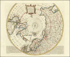
Fascinating (and entirely speculative) map of the Antarctic Regions, based upon the map of Philippe Buache, publlished in Paris.
The map is perhaps most notable for the renewed speculation regarding lands of the southern polar regions. Still entirely undiscovered, French map makers had taken a renewed interest in the prospects of the lands of the unknown southern continent in the middle part of the 18th Century. For example, the present map shows "Terre de Goneville" a reference to the discovery of Antarctica by a French explorer named Gonneville in 1504. The French explorer Captain Binot Paulmyer de Gonneville claimed to have discovered the southern continent in 1504. He stayed six months and found the natives "asked nothing but to lead a life of contentment, without work." He brought back skins, ornaments, and an Indian prince named Essomeric. Historians believe that Gonneville was probably in southern Brazil.
In the interior of the imagined southern continent, Buache postualates a large Antarctic Sea, which was inspired in part b the 1738-9 expedition of Bouvet de Lozier, which mentions the discovery of icebergs between two and three hundred feet high and half a league to two or three leagues in circumference. Buache placed Bouvet's Cap de la Circoncision at 54° south, below Africa, a northern promontory of the smaller of his two land masses, next to one of the openings of his polar sea, where Bouvet had recorded his many great icebergs. Buache also shows the route of the voyage of Abel Tasman (1603-1659) in 1642-3 as a source for information about the southern lands. Buache believed that the icebergs must have derived from a floating ice sheet, as in the Arctic, rather than from the newly discovered land. This led him to conclude that the southern continent was not a single landmass but two islands separated by a frozen inland sea, from which icebergs detached themselves to float northwards.
The sea shown in the center of Antarctica was based upon a hypothesis Buache had developed over a number of years. His paper 'Geographical and physical observations, including a theory of the Antarctic regions and the frozen sea which they are supposed to contain' was published by The Gentleman's Magazine in 1763. In it, he hypothesised that the southern pole must contain a frozen sea, fed by mountain ranges and huge rivers, in order to produce icebergs of the size reported by Bouvet; the large sea (Mer Glacial, 'Glacial Sea') depicted on the 1739 map is an early version of this hypothesis.
Buache was an academic geographer who researched his material thoroughly, relying on the most up-to-date information from voyages of discovery. He was the first geographer to recognize the important concept of the watershed and it was this that led him to make a number of deductions, some correct, some not. A correct deduction was the existence of Alaska and the Bering Strait, years before they were officially discovered, while an incorrect deduction was the existence of a central Antarctic sea, which he conjectured to be the source of the icebergs observed by Bouvet in 1738-39.
There are those, including Hapgood, who see Buache's map as a tie in to the Piri Reiss map in the argument that these maps depict a subglacial land mass that is the Antarctic.
The Gentleman’s Magazine was a British publication that helped to normalize the use of maps in support of articles and features. It was founded in 1731 by the prominent London publisher Edward Cave, a pioneer in periodical journalism. The magazine continued in print for nearly two centuries, shuttering production in 1922.
This was the publication which first used the word “magazine”, from the French for storehouse. Cave wanted to create a storehouse of knowledge and he employed some of London’s best writers to fill his pages: Samuel Johnson gained his first regular employment by writing for the Gentleman’s Magazine. Other famous contributors included Jonathan Swift.
The publication covered a broad range of topics, from literature to politics, and, from 1739, frequently used maps as illustrations. The first map they printed was a woodcut of Crimea; the second was a fold-out map of Ukraine by Emanuel Bowen. Maps were used to show battle lines, to chronicle voyages, and to educate about areas with which Britain traded. Certain geographers, like Thomas Jefferys, contributed several maps to the publication.
![[ Antarctica ] [Signed and Annotated by Robert A. English, Commanding Officer of the Bear of Oakland] Reconnaissance Map. King Edward VII Land. The Northern Part of Marie Byrd Land. Based mainly on air photographs taken by Capt. A.C. McKinley on the Byrd Antarctic Expedition 1928-1930 . . .](https://storage.googleapis.com/raremaps/img/small/89439.jpg)
![[ Eastern Hemisphere Globe Gores. ] (Nova et integra universi Orbis descriptio)](https://storage.googleapis.com/raremaps/img/small/54480.jpg)
![[ Discovery of the Northwest Passage ] Chart Showing the Recent Search for a North-West Passage. Also the Coast Explored in Search of Sir John Franklin between the Years 1848 and 1854](https://storage.googleapis.com/raremaps/img/small/101874.jpg)