|
||

|

|
|

|
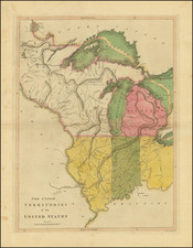
Rare early map of the region west of Lake Superior focused on the area controlled by the Northwest Company, which appeared in Alexander M'Donell's A narrative of transactions in the Red River Country; from the commencement of the operations of the Earl of Selkirk . . . published in London in 1819.
The map identifies the US-Canada Border based upon the Convenion of 1818 and shows many of the North West Company's trading posts. The Explanation notes that it shows
- The Route of the Fur Traders from Fort William to the different Trading Posts in the interior of the North West Company
- Territory Claimed by Lord Selkirk in virtue of a Grant from the Hudson's Bay Company
The map is apparently very rare. In G.C. Davidson's The North West Company (1918), we find the following note at page 146.
Part of the Selkirk grant is shown in a printed map in the British Museum entitled "A Map of Part of the Indian Territories in North America exhibiting the route of the Indian Fur Traders from Fort William to the Red River, and to the other Trading Stations of the North West Company." It has an inset plan of the ground near the Forks of Red River with route-marks to show the movements of June 19, 1816. evidently delineated in the interest of the North West Company. The map is undated, but is not earlier than 1818, as it shows the boundary line adopted by the Convention of 1818. It shows thirty North West Company trading-posts marked as such, besides Cumberland House, which is not so marked. These are mostly on the waters between Lake Superior and the Saskatchewan, and on the Red and Assiniboine rivers and their branches.
The entry in Wagner-Camp notes:
M'Donell says he entered the employ of the Hudson's Bay Company at Red River in September 1809. While serving as a clerk for the North West Company in 1812, he encountered the first of Lord Selkirk's emigrants and afforded them assistance in their distress during that winter, only to regret their coming when their leaders later turned on the traders. A large part of the narrative deals with these troubles, and in fact was written in defense of the actions of the North West Comppany. There is some account of affairs farther west, at Ash House on the Ri\aere la Sourie, on the Qu' Appele River and other interior stations which appear on the valuable map.
We note that the last complete example of the book at auction was at Sothebys in 1969, where the book sold for $528.00.
![[The Final State] A New Map of North America, with the West India Islands, Divided according to the Preliminary Articles of Peace, Signed at Versailles, 20 Jan. 1783, wherein are Distinguished The United States and the Several Provinces, Governments &c Which Compose the British Dominions . . . 1794](https://storage.googleapis.com/raremaps/img/small/89085.jpg)

![[An English Propaganda Map In French] Carte Des Possessions Angloises & Francoises Du Continent De L'Amerique Septentrionale 1755.](https://storage.googleapis.com/raremaps/img/small/86975.jpg)