|
||

|

|
|

|
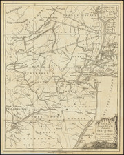
Fine map of the Southern British Colonies, at the conclusion of the American Revolution.
The map appeared in Sir Banastre Tarleton's A History of the Campaigns of 1780 and 1781, in the Southern Provinces of North America . . ., published in London in 1787.
The map details Cornwallis' march south after the conclusion of the Phlladelphia Campaign, where following initial successes leading the British in the South, Cornwallis would ultimately surrender to George Washington at Yorktown.
The map includes a key identifying the following marches:
- Red-Lord Corwnwallis
- Blue-Brigadier General O'Hara
- Yellow: Colonel Banastre Tareleton
Charles, Earl Cornwallis (1738-1805), was a military officer who served in the British Army during the American War of Independence. He is best known for surrendering his army after the 1781 Siege of Yorktown, an act that ended major hostilities in North America and led directly to peace negotiations and the eventual end of the war.
Born into an aristocratic family with a history of public service, Cornwallis was politically opposed to the war, but agreed to serve when it became clear that Britain would require a significant military presence in the Thirteen Colonies. First arriving in May 1776, he participated in the Battle of Sullivan's Island, before joining the main army under General William Howe. He played a notable role in the partially successful New York and New Jersey campaign when George Washington, successfully eluded him after the Battle of the Assunpink Creek and inflicted a decisive defeat on troops left at his rear in the Battle of Princeton.
Cornwallis was also involved in the Philadelphia campaign (1777-1778), leading a wing of Howe's army, before he became one of the leading figures of the British "southern strategy" to gain control of the southern colonies. In that role, he successfully led troops that gained a measure of control and influence in South Carolina before heading into North Carolina. There, despite successes like his victory at the Battle of Camden, which burnished his reputation, wings of his army were decisively defeated at Kings Mountain and Cowpens. After an inconsequential victory at Greensboro, North Carolina, Cornwallis moved his battered army to Wilmington to rest and resupply.
From Wilmington, Cornwallis, in a move that became a subject of contemporary and historical debate, led his army into Virginia, where he joined with other British troops that had been raiding economic and military targets in that colony. Ineffectually opposed by a smaller Continental Army under the Marquis de Lafayette, he was eventually ordered to establish a well-defended port by General Henry Clinton. Poor communications in the British establishment and French naval superiority over the Chesapeake Bay caused him to become entrapped at Yorktown without the possibility of reinforcement; he surrendered after three weeks of siege, on October 17, 1781. He was released on parole, and returned to England in December of that year. He and General Clinton engaged in a highly public exchange after the 1781 campaign in which each sought to deflect blame for its failure.
William Faden (1749-1836) was the most prominent London mapmaker and publisher of the late-eighteenth and early-nineteenth centuries. His father, William Mackfaden, was a printer who dropped the first part of his last name due to the Jacobite rising of 1745.
Apprenticed to an engraver in the Clothworkers' Company, he was made free of the Company in August of 1771. He entered into a partnership with the family of Thomas Jeffreys, a prolific and well-respected mapmaker who had recently died in 1771. This partnership lasted until 1776.
Also in 1776, Faden joined the Society of Civil Engineers, which later changed its name to the Smeatonian Society of Civil Engineers. The Smeatonians operated as an elite, yet practical, dining club and his membership led Faden to several engineering publications, including canal plans and plans of other new engineering projects.
Faden's star rose during the American Revolution, when he produced popular maps and atlases focused on the American colonies and the battles that raged within them. In 1783, just as the war ended, Faden inherited his father's estate, allowing him to fully control his business and expand it; in the same year he gained the title "Geographer in Ordinary to his Majesty."
Faden also commanded a large stock of British county maps, which made him attractive as a partner to the Ordnance Survey; he published the first Ordnance map in 1801, a map of Kent. The Admiralty also admired his work and acquired some of his plates which were re-issued as official naval charts.
Faden was renowned for his ingenuity as well as his business acumen. In 1796 he was awarded a gold medal by the Society of Arts. With his brother-in-law, the astronomer and painter John Russell, he created the first extant lunar globe.
After retiring in 1823 the lucrative business passed to James Wyld, a former apprentice. He died in Shepperton in 1826, leaving a large estate.

![[ Florida Indians - Destroying the Enemy's Towns By Night ] Hostium oppida noctu incendendi ratio. XXXI.er absagen](https://storage.googleapis.com/raremaps/img/small/97385.jpg)
![[Ascension Island] The True Description of the Island of Ascention lyeing under 8 degrees on ye South syde of ye Equinoctiall lyne.](https://storage.googleapis.com/raremaps/img/small/78964.jpg)