|
||

|

|
|

|
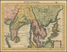
Doncker's Wall Map of the Indian Ocean in the 2 Sheet Sea Atlas Configuration
Fine old color example of of Doncker's important Wall Map / Sea Chart of Australia, the Indian Ocean etc., one of the first maps to show information from Abel Tasman's 1644 Voyage.
Originally planned as a wall map and then later printed in 2 sheet atlas format by masking off the extra portions of the plate and adding 2 title cartouches, Doncker's wall map of the Indian Ocean, shows Tasman's discoveries on the Australian continent for one of the first times on a printed map. Doncker's chart would become the standard representation of Australia for the next 60 years, as the model of all Dutch cartography of the area.
The chart includes details of the Dutch discoveries in Australia of Hartog (1616); Houtman (1619); the Leeuwin (1622) and Carstenszoon (1623); as well as de Wits (1628); and Tasmans second voyage in 1644 (Northern Australia) and Peter Nuyts exploits (1627) (Gowrie Gallery, Printed World III, 2000).
The present example is the extremely rare second state, which the first to include the addition of title cartouches on the two sheets. A later state was issued in 1666 and still another with a completely revised cartouche, issued about 1680. All editions are very rare, in part because they were probably originally issued separately and only later included in Doncker's Atlases. In his recent census of Doncker Atlases, Jason Hubbard noted that not only were the map sheets oversized (ie. larger than the other maps which appeared in Doncker's atlas), the plates were masked at the edges in the printing process and therefore lack the normal plate marks (further evidence that the primary intention when the plates were initially engraved was to issue the pair in wall map format).
The map was first identified by the important 19th Century Book & Map dealer, Frederik Muller. In 1872, Muiler catalogued a copy of the Doncker atlas dated 1659 (Muller, America, III, nr 1934. 1872). This atlas is given by Koeman as the first Doncker atlas with a world map (Claes Janszoon Visscher, dated 1652) and included 17 charts. Among these charts were 2 sheet charts of both the East Indies and West Indies (Muller 1872, compare also Koeman IV Don 1).
Muller's cataloging of the map in 1896 stated as follows:
La premiere edition de 1659 contient 17 cartes parmi lequelles le plus remarquable est celle des Indes Orientales en deux feuilles. Cette carte donne les decouvertes faites par Tasman en 1644....elle est la premiere carte marine qui donne les decouvertes de l Australie de 1644.
[Our Translation: The first edition of 1659 contains 17 charts, among which the most notable is that of the East Indies in two sheets. This map shows the discoveries made by Tasman in 1644 .... it is the first chart that shows [Tasman's] discoveries of Australia of 1644].
In 1894, the Muller company issued a facsimile atlas with rare maps from the Bodel Nyenhuis collection. In part III (Australia) the Doncker map is copied from the 1660 edition (with title cartouche). In the accompanying text it is stated that " in the first Dutch edition of the Doncker Zeeatlas of 1659 the chart was given without either title or cartouche…." The text in the Zeeatlas of 1660 tells us about Australia that: we will call Terra Australis those countreys in the south of Nova Guinea, whether (sic = where) the Hollanders most zayeld (sec= sailed) in the year 1644, and in these our maps are called Nova Hollandia and Nova Zeelandia……"
Hendrik Doncker was a prominent bookseller in Amsterdam best known for his sea charts and nautical atlases. He issued his own original charts, which he updated frequently, and also worked with colleagues like Pieter Goos, for example to produce the pilot guide, De Zeespeigel. He died in 1699, after fifty years in business. His plates then passed to Johannes van Keulen.
![Aden Arabiae Foelicis Emporium Celeberrimi Nominis, quo ex India, Aethiopia ... [on sheet with] Mombaza [and] Quiloa [and] Cefala](https://storage.googleapis.com/raremaps/img/small/54473mp2.jpg)
![[ Cyprus, Syria, Palestine, etc. ]](https://storage.googleapis.com/raremaps/img/small/103027.jpg)
![[Okeania] (Greek)](https://storage.googleapis.com/raremaps/img/small/41765.jpg)
![[Democratic Republic of the Congo] Congo Belge](https://storage.googleapis.com/raremaps/img/small/77991.jpg)