


|
||

|

|
|

|
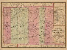
Extremely early1879 first edition of Cram's first map of Wyoming Territory.
One of the few obtainable maps of Wyoming showing only 5 counties, illustrating the earliest township surveys within the Territory. The map shows Wyoming shortly after Custer's expedition (1876), the arrival of the Arapahoe to the Wind River Reservation (1877) and the Chief Joseph's attempt to lead the Nez Perce to Canada by way of Yellowstone, etc (1877).
The map includes numerous place names along the Union Pacific Railroad line, as well as Ft. Laramie, Ft. Halleck, Ft. Fetterman, Ft. Casper, Ft. Reno, Ft. Phil Kearney, Ft. Conner, Ft. Thompson, Ft. Bridger and Ft. Bonneville.
Excellent detail in Yellowstone, including over a dozen place names. Sweetwater County, Miner's Delight, Atlantic Cy, Camp Stambaugh and South Pass Cy are also named.
George Cram would become one of the most prolific atlas publishers of the last 19th and early 20th Centuries. His earliest maps, issued in the late 1860s, were marvelous separately issued railroad maps. His success led to the publication of two editions of his now very rare New Commercial Atlas of the United States in 1875 and 1879, which included a number of Cram's rare separately issued railroad maps. This first issued in 1875, Cram's pre-1880 map of Wyoming is among the rarest of all maps of Wyoming to appear in a commercial atlas,
This is the first example of the 1879 edition of the map we have handled. Washington Territory on the verso.
George F. Cram (1842-1928), or George Franklin Cram, was an American mapmaker and businessman. During the Civil War, Cram served under General William Tecumseh Sherman and participated in his March to the Sea. His letters of that time are now important sources for historians of the Civil War. In 1867, Cram and his uncle, Rufus Blanchard, began the company known by their names in Evanston, Illinois.
Two years later, Cram became sole proprietor and the company was henceforth known as George F. Cram Co. Specializing in atlases, Cram was one of the first American companies to publish a world atlas. One of their most famous products was the Unrivaled Atlas of the World, in print from the 1880s to the 1950s.
Cram died in 1928, seven years after he had merged the business with that of a customer, E.A. Peterson. The new company still bore Cram’s name. Four years later, the Cram Company began to make globes, a branch of the business that would continue until 2012, when the company ceased to operate. For the final several decades of the company’s existence it was controlled by the Douthit family, who sold it just before the company was shuttered.

![The Mines of Colorado [with:] Map of Colorado Territory to accompany Hollisters](https://storage.googleapis.com/raremaps/img/small/100860.jpg)
![[ Karte des Nordens von America, Zur Beurtheilung der Wahrscheinlichkeit einer nord=westlichen Durchfhart, gezeichnet von G. Forster, 1791.]](https://storage.googleapis.com/raremaps/img/small/41816dm.jpg)