|
||

|

|
|

|
Striking battle plan of Gibraltar, showing the positions of the English and Spanish forces during the battles of 1781 and 1782.
Faden's map of the battle at Gibraltar is a remarakble bit of engraving, including tremendous military detail based upon on the spot accounts of the battle with the topographical detail of the best available contemporary surveys of the region.
Among the more colorful annotations and illustrations are the battering ships, fire ships, and the position of the enemies' combined fleet. The map shows anchorages, soundings, battle lines, encampments, roads, towns, and a host of other details, in remarkable clarity.
The Great Siege of Gibraltar was an unsuccessful attempt by Spain and France to capture Gibraltar from the British during the American War of Independence. This was the largest action fought during the war in terms of numbers, particularly the Grand Assault of September 18, 1782. It was the longest siege endured by the British Armed Forces, as well as being one of the longest continuous sieges in history.
This is the second edition of the map, which was originally engraved by Faden in 1781 and lacked all of the battle information.
William Faden (1749-1836) was the most prominent London mapmaker and publisher of the late-eighteenth and early-nineteenth centuries. His father, William Mackfaden, was a printer who dropped the first part of his last name due to the Jacobite rising of 1745.
Apprenticed to an engraver in the Clothworkers' Company, he was made free of the Company in August of 1771. He entered into a partnership with the family of Thomas Jeffreys, a prolific and well-respected mapmaker who had recently died in 1771. This partnership lasted until 1776.
Also in 1776, Faden joined the Society of Civil Engineers, which later changed its name to the Smeatonian Society of Civil Engineers. The Smeatonians operated as an elite, yet practical, dining club and his membership led Faden to several engineering publications, including canal plans and plans of other new engineering projects.
Faden's star rose during the American Revolution, when he produced popular maps and atlases focused on the American colonies and the battles that raged within them. In 1783, just as the war ended, Faden inherited his father's estate, allowing him to fully control his business and expand it; in the same year he gained the title "Geographer in Ordinary to his Majesty."
Faden also commanded a large stock of British county maps, which made him attractive as a partner to the Ordnance Survey; he published the first Ordnance map in 1801, a map of Kent. The Admiralty also admired his work and acquired some of his plates which were re-issued as official naval charts.
Faden was renowned for his ingenuity as well as his business acumen. In 1796 he was awarded a gold medal by the Society of Arts. With his brother-in-law, the astronomer and painter John Russell, he created the first extant lunar globe.
After retiring in 1823 the lucrative business passed to James Wyld, a former apprentice. He died in Shepperton in 1826, leaving a large estate.
![[ El Escorial - Madrid ] Scenographia Totius Fabricae S. Laurentii In Escoriali](https://storage.googleapis.com/raremaps/img/small/87916.jpg)
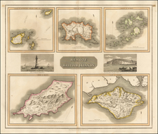
![[ British Islands ] Wight / Scilly / Jersey / Guernsey / Alderney / Man / Holy / Farne ] The Smaller Islands in the British Ocean](https://storage.googleapis.com/raremaps/img/small/98973.jpg)