|
||

|

|
|

|
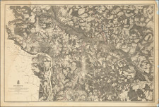
Scarce map of the City of Norfolk, published in Norfolk in 1891, apparently distributed by Myers & Co. Real Estate of Norfolk.
The map was printed and annotated at a time when the Lambert Point area was growing quickly, as a result of the explosion of the coal distribution industry.
The map shows the details of the city proper, extending south to Portsmouth and South Norfolk and to just north of Tanners Creek. The land owned by a number of company's is shown, including:
- Lambert's Point Water Front Co.
- Lambert's Point Central Land Co.
- River Front Land Co.
- Norfolk Developing Co.
- North Norfolk Co.
- Lambert Point Investment Company
- Norfolk Wtaer Front Development Co.
- Colley AVe. & Lambert's Point Co.
- Central Land Co.
- Enterprise Land Co.
- Norfolk Terminal Land Co.
- New Norfolk Land Co.
- Norfolk Land Improvement Company
- Saftey Land Co.
- Port Norfolk Land Company
Lamberts Point was named for Thomas Lambert, who patented 100 acres on the east side of the bay of the Elizabeth River on June 1, 1635, when the territory was still a part of Elizabeth River Shire in colonial Virginia.
The development in the Lambert area reflects the boom times in the coal industry. In 1883, the first car of bituminous coal arrived from the Pocahontas fields over the Norfolk & Western Railway and by 1886 the tracks were extended right up to the coal piers at Lambert's Point to handle the increasing volume, creating one of the largest coal transshipment ports in the world.

![[ Florida Indians - Destroying the Enemy's Towns By Night ] Hostium oppida noctu incendendi ratio. XXXI.er absagen](https://storage.googleapis.com/raremaps/img/small/97385.jpg)