|
||

|

|
|

|
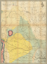
Finely detailed birdseye view styple map of the Cripple Creek Mining District, published by the Williamson-Haffner Engraving Company of Denver Colorado.
The map extends from the El Paso-Fremont County Line to Mount Nell, Mt. Cleveland, North Peak and Mt. McCart. The focal point of the map is stamped in Red, showing the Rockford Gold Mining and Milling Company. mining claims, just above Cripple Creek.
Towns shown with town plans include:
- Cripple Creek
- Victor
- Gillett
- Gold Field
Railroads located include
- Florence & Cripple Creek R.R.
- Midland Terminal R.R.
The map packs a tremendous amount of mining details, roads, rivers, etc.
Shows topographical features, cities, railroads, and mines. By The Williamson-Haffner Engraving Co., Sherman Building, Denver. One red highlight shows the Rockford Gold Mining and Milling Company. The back is a prospectus on the mine. The mine turned out to have no value and in 1901 three men were arrested for selling worthless stock. The Rockford was one of the company stocks they were trying to peddle.