|
||

|

|
|

|
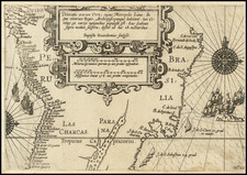
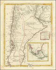
Fine Map of South America by Jaillot
Handsome large-format map of South America, based upon the earlier maps of Nicholas Sanson.
Jaillot’s map is well-framed, showing South America with portions of Central America, Africa, and the Cape Verde Islands.
The continent’s defining physical features are notable here. The Rio de la Plata curls northwards, studded with islands, and ends in the mythical Lake of Xarayes. The Amazon winds towards the heart of the landmass, splitting into a feather-like pattern and then weaving its way from smaller rivers in Peru. In the north is a large, rectangular lake, Lake Parime, with the mystical city of Manoa El Dorado on its banks.
In the far south, the Straits of Magellan separate Tierra del Fuego from the mainland. The latter is shown as a single island with several rivers, a common depiction of the area at the time. The Straits are surrounded by toponyms of Spanish, Dutch, and English origins. This reflects the dense history of navigation in the area, with Magellan—a Portuguese sailor in the employ of the Spanish—naming Cape of 11,000 Virgins, Jacob Le Maire naming Staten Land and the Straits of Le Maire, and John Narbrough naming Cape Froward, as some examples.
The geographic content of the map is augmented by the decorative features. In the lower right corner is an imposing scale bar. Framing it are indigenous women lounging, crying, and vomiting. Below them is a monkey and some tropical birds. In the lower left is the title cartouche crowned by two impressively-dressed native men. They gesture toward the coat of arms of the Dauphin of France, the dedicatee of the map.
Jaillot’s map is one of the most detailed and accurate maps of the period.
One of the defining features of this and many maps of South America is a massive lake in the north, near Guiana. This is Lake Parime, a feature long-connected to the El Dorado myth. Rumors of a golden city in the New World were first tied to an initiation ceremony for a new chief of the Chibcha (Muisca) people. Bejewelled and covered in gold dust, the chief was supposedly ritually cleansed in sacred Lake Guatavita while more precious stones and metals were thrown into the water. El Dorado, as described by sixteenth and seventeenth-century chroniclers like Oviedo, Castellanos, and Freyle, was a reference to this “golden man.”
Quickly, the golden man was spun into stories of a golden city, which was supposed to perch on the shores of a vast lake. The precise location of both lake and city varied, however. Some searched in the Andes, others the interior. Gonzalo Pizarro set out east of the Incan Empire to find the city and instead lost nearly all of his 4,000 mean. One of his officers, Orellana, was ordered to continue the search and he eventually reached the Atlantic via the Amazon, the first European to do so.
Still others thought the lake and rich city must be near the Orinoco River. Expeditions in this area reached the ears of Sir Walter Raleigh, who led an expedition to Guiana in 1595. While his search failed, Raleigh sent another man, Lawrence Keymis, the next year. Keymis brought back word that a rich city, Manoa, did exist and that it was located on the shores of a Lake Parime. Raleigh published the information in his voyage account, thus popularizing Lake Parime as a geographic feature.
The lake appeared on maps from 1596 until the eighteenth century. The first was Jodocus Hondius’ Nieuwe Caerte van het Wonderbaer ende Goudrycke Landt Guiana. The lake is usually shown as a rectangular body of water on or near the Orinoco River as it approaches the equator. This quadrilateral of a lake is based on the interpretation of the body of water by Hessel Gerritsz in his 1625 Guiana sive Provinciae. While fewer and fewer maps featured the lake as the eighteenth-century wore on, the story was not disproven until the travels of Alexander von Humboldt in South America (1799-1804).
Alexis-Hubert Jaillot (ca. 1632-1712) was one of the most important French cartographers of the seventeenth century. Jaillot traveled to Paris with his brother, Simon, in 1657, hoping to take advantage of Louis XIV's call to the artists and scientists of France to settle and work in Paris. Originally a sculptor, he married the daughter of Nicholas Berey, Jeanne Berey, in 1664, and went into partnership with Nicholas Sanson's sons. Beginning in 1669, he re-engraved and often enlarged many of Sanson's maps, filling in the gap left by the destruction of the Blaeu's printing establishment in 1672.