This item has been sold, but you can enter your email address to be notified if another example becomes available.


|
||

|

|
|

|
Stock# 41645
Description
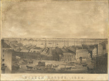
Nice example of the Wall Map version of Reverend F.C. Ewer's Historical Map of Nantucket.
The map illustrates the various place names, roads and townships on the island, along with extensive historic Native American and European settler's information.
The map features three columns of text breaking down the history of Nantucket from its discovery by Bartholomew Gosnold in 1602, to the laying of the first communications cables between Nantucket and the mainland in 1886.
As noted by Garver:
It is not clear exactly what prompted the Reverend Ewer to design his historical map of Nantucket. Although he had spent many years of his youth on the island, where his family had deep roots, he had long since left it behind. After graduating from Harvard, he had tried his hand unsuccessfully at several occupations in California (panning for gold, making maps for a civil engineer, and working as a reporter) before experiencing a barroom conversion and entering the ministry. His religious duties then took him to New York City, where he served as rector of several churches.
Ewer's map provides a detailed synopsis of Nantucket's history, beginning with Gosnold's sighting of the island in 1602. The chronological table identifies the major stages in Nantucket's development-its early settlement and land divisions, the evolution from shore to deep-sea whaling, the establishment of religious and educational institutions, and the development of the transportation network connecting Nantucket with the mainland (and Nantucketers with one another). Ewer also notes events that marked the transition from one era to the next-the first island whaler to seek its prey in the Pacific (1791), the death of the last Indian (1822), the great fires of 1836 and 1846, and the first gaslight in 1854. In more graphic form the map indicates the sites of old settlements and burial grounds, as well as the boundaries of sachem rights, the former shoreline, old fishing stages, and whaling stations." (Surveying the Shore, p.115)
A fine example of the only reasonably obtainable wall map of Nantucket.
Condition Description
Wall map, cleaned and restored, with normal cracking, etc.
Reference
Crosby, Nantucket in Print, pp. 224-225. Garver, Surveying the Shore, pp.114-115.
![[Special Promotional / Sample Map for Rand McNally Business Atlas] Massachusetts](https://storage.googleapis.com/raremaps/img/small/89042.jpg)
![Carte Reduite Des Costes Orientales De L'Amerique Septentrionale . . . contenant L'Isle Royale . . . La Nouvelle Angleterre et la Nouvelle Yorc . . . MDCCLVII [with Plan of Boston Harbor] Plan du Havre de Baston](https://storage.googleapis.com/raremaps/img/small/80006.jpg)