![The Map of China [Huang Ming yitong fang yu bei lan -- Comprehensive view map of the Imperial Ming] By Samuel Purchas](https://storage.googleapis.com/raremaps/img/small/99110.jpg)


|
||

|

|
|

|
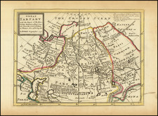
Fine dark impression of the Purchas map of China, which is widely regarded as the first map of China western published map to have been derived directly from Chinese sources.
The Purchas map of China is based upon a Chinese woodblock sheet map, which had been acquired by Captain John Saris in Bantam sometime between December 1608 and October 1609. Saris, then serving as chief factor in Bantam for the East India Company, had taken it from a Fujianese merchant in partial settlement of a debt owed to Saris. Saris in turn delivered the map to Richard Haklyut, who in turn gave the map to Purchas during the time period when Purchas was translating Hugo Grotius' Mare Liberum.
Purchas included the map in his 1625 Hakluytus Pothumus or, Purchas his Pilgrimes, a collection of travel writings, based on the work of the famous geographer, Richard Hakluyt (1552-1616). Purchas refers to the map as
The Map of China, taken out of a China Map printed with China characters, etc. gotten in Bantam by Capt. John Saris.
The title transliterates as "Huang Ming yitong fang yu bei lan," meaning Comprehensive view map of the Imperial Ming. The original Saris-Haklyut-Purchas map was written entirely in Chinese. Because Purchas could not translate the map, he removed the Chinese characters from the body of the map, using symbols to depict the towns, rivers and mountains.
It is possible that this Chinese map was the 1593 "Cao Map", of which there is now only one recorded example.
Squares and circles depict cities and settlements. The provinces of China are marked and boundaries shown, for perhaps the first time on a Western map. Macau and Canton (Guangzhou) are both named. The vignettes in the corners depict Matteo Ricci and a Chinese couple.
This map would serve as a model for the later maps by De Bry and Semedo and would be of tremendous influence in the early part of the 17th Century. The general construction of the map is a significant improvement from Ortelius' map of China of 1584, which is drawn directly from reports of the Portuguese mapmaker Luis Jorge de Barbuda (Ludovicus Georgius), who made a manuscript map of China which reached Ortelius via Arias Montanus.
A nice example of this map of landmark importance in the history of the mapping of China.
Samuel Purchas (bap. 1577-1626) is one of the most famous geographers and editors in English history. His important Hakluytus Posthumus served as a source for subsequent geographers for over a century. Purchas was baptized in Thaxted, Essex in 1577, the sixth of ten children. He attended university at St. John’s College, Cambridge and graduated with a BA in 1597 and an MA in 1600. Highly educated, Purchas dedicated his skills to serving as a clergyman in the Church of England. He was ordained as a deacon in 1598 and as a priest in 1601. After serving in several parishes, he became chaplain to Archbishop George Abbot in ca. 1613, the first of several London appointments. At King James’s College, Chelsea, he wrote his only published sermon.
It was at King James’s College that he also composed much of his master work, Hakluytus Posthumus, or, Purchas his Pilgrimes (1624–5). Purchas called upon his relationship with his famous predecessor in travel editing, Richard Hakluyt. In 1620, Purchas acquired the remaining manuscripts collected by Hakluyt and these form the basis for his own work. When it was published, it took three years to print and was the largest book ever published in England. Purchas not only edited and compiled the travel accounts covering Europe, Asia, Africa, and the Americas, but he added anti-Catholic commentary of his own. He died in 1626, shortly after the volumes appeared.
Purchas is important not only as a source for geographers, but for the maps included in his travel collection. The first edition contained nearly ninety maps, some of which were completed by Jodocus Hondius. Not all the maps were original, but there are nevertheless several highly influential maps. For example, the famous John Smith Map of Virginia featured in Purchas’ work. Purchas also included the Henry Briggs Map of North America, the first map in English to show California as an island, as well as the first map to name Hudson’s Bay and the Hudson River. Additionally, there is the William Alexander Map of the Northeast, which pioneered many new place names; Roe’s map of North India, the earliest English map of Mogul lands; and Saris’ map of China, which shows Korea as a peninsula.