This item has been sold, but you can enter your email address to be notified if another example becomes available.


|
||

|

|
|

|
Stock# 41509
Description
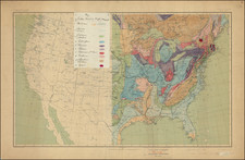
This seems to be a very early edition of a map that was issued as a base map for more than 20 years and was later reprinted in 1975.
Includes a Note. This map is mainly reduced from the official map, compiled in the Office of Explorations to exhibit Pacific Rail Road Routes, War Dept., and from Colton's Maps of the several states"
The map provides a highly detailed study of the various rivers draining into the Mississippi River, based upon the most up to day information.
The map includes red overprinting, noting annual rainfall.
Condition Description
Overprinted in Color.

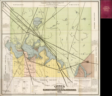
![[ Southern California Water Explorations ] Topographical Sketch showing the Outward and Inward Route of A Party, while examining the practicability of a Diversion of the Colorado River for Purposes of Irrigation under the Command of 1st Lieut. Eric Bergland Corps of Engineers, U.S. Army 1875](https://storage.googleapis.com/raremaps/img/small/98208.jpg)