


|
||

|

|
|

|
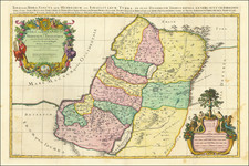
Striking large format map of the Holy Land, with tribal divisions and a wealth of place names and topographical detail, including the locations of royal and priestly cities, and sanctuaries.
Decorated with two fine cartouches. The title cartouche includes four figures; at top Moses and Aaron flank the royal coat of arms, and at bottom a Roman soldier and a pagan figure appear on either side of the Arc of the Covenant. The lower mileage-scale cartouche features Adam and Eve in the Garden of Eden.
Pierre, or Pieter, Mortier (1661-1711) was a Dutch engraver, son of a French refugee. He was born in Leiden. In 1690 he was granted a privilege to publish French maps in Dutch lands. In 1693 he released the first and accompanying volume of the Neptune Francois. The third followed in 1700. His son, Cornelis (1699-1783), would partner with Johannes Covens I, creating one of the most important map publishing companies of the eighteenth century.
![Syria (North Division) [with] Syria (South Division) including Palestine & the Hauran.](https://storage.googleapis.com/raremaps/img/small/89072.jpg)
![Carte De La Syrie [Shows Cyprus and the Holy Land!]](https://storage.googleapis.com/raremaps/img/small/61321.jpg)